A great place to sit and enjoy the ambiance with an excellent coffee and an exquisite cake.
Graham’s Guidelines
* Rating (1 to 5)
Coffee
4*
Food
5*
Conversation
3*
People Watching
5*
Grasmere has several excellent cafes and is, thankfully, devoid of corporate establishments.
Mathilde’s is on the same site, and shares the building with the Heaton Cooper Studio which is itself a Lake District icon. It also has the advantage of being on the route for several great walks from Grasmere. It’s right next to Easedale Road which is on the route of both the Helm Crag and the Sourmilk Gill/Easedale Tarn routes.
The decor of the cafe is heavily influenced by the Heaton Cooper artwork with prints on the wall, in the colour pallet of the furniture and even in the print on the light shades.
There’s a good seating area outside, but my favourite seat is right next to a large window with a view across the fells towards Stone Arthur and Rydal Fell.
Mathilde’s is named after the Norwegian wife of Alfred Heaton Cooper the patriarch of the artistic Heaton Cooper dynasty. Mathilde’s Scandinavian roots are also reflected in the menu at the cafe – here can’t be many places in the Lake District that offer smoked trout with the brunch menu. They do also serve Cumberland sausages and bacon.
The cakes at Mathilde’s are exquisite and just right for an end of walk celebration. This isn’t the place for giant slabs of cake, but is the place to possibly experience something a little different.
The coffee is good, serving Carvetii which is roasted in Threlkeld outside Keswick to the north.
Mathilde’s is an excellent place for people watching, particularly if you convince the people you are with to let you have a seat overlooking Moss Parrock, the small square opposite the cafe. Grasmere is a wonderfully eclectic mix of people on most days.
There are the walks, like myself, who are only passing through the village or stopping for a short refreshment break. Many of the walkers are families with plenty of children being chivied along by parents, promising a cafe stop on their return from whichever route that has been chosen.
The village is also a regular on the coach tours frequented by an older clientele. Last time I was sat at Mathilde’s there was a moment when everyone outside appeared to be walking slowly. It was only on closer inspection I realised that it was a squadron of zimmer frames making their way to somewhere in formation.
Grasmere, mainly because of its Wordsworth connections, is also a favourite of groups from more eastern countries. When I see the volume of photographs being taken I do feel sorry for the friends who will have to look through them on their return.
There are many cycling routes that pass through Grasmere making it a favourite of the lycra-clad-two-wheel-gangs.
The area also has a reputation as a great place for a romantic get-away, last time I was in Mathilde’s there was a couple for whom that was the case, although, from the conversation all was not going quite to plan.
Mathilde’s is definitely worth sitting a while.
I’ve marked this one a 3* for conversation, but that’s only because I was in there on my own. Although, having said that, I do quite like talking to myself.
Mathilde’s Cafe, Heaton Cooper Studio, Grasmere, Ambleside LA22 9SX
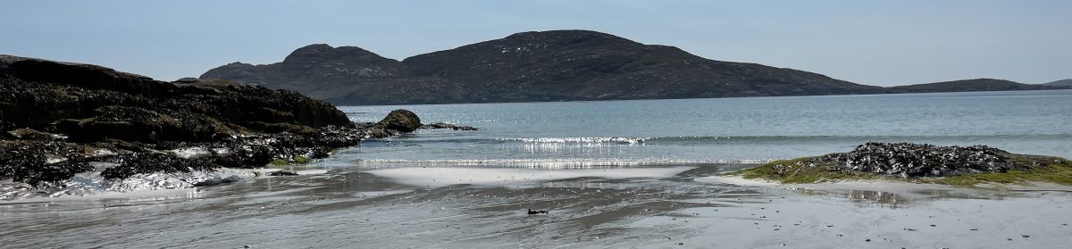
Helm Crag, while not one of the highest peaks in the Lake District, is one of the better known ones. The rocky outcrop that sits at the end of the ridge has a shape that provokes several nicknames. The shape of the outcrop have provoked popular names the Lion and Lamb and The Old Woman Playing the Organ depending on where you are viewing it. I have no idea why it’s an Old Woman the shape isn’t that specific, the Lion and Lamb reference is from the Bible and makes sense from certain directions. While this rock formation is distinctive, it’s not the summit, that’s a bit further along.
This walk starts from the valley where it can be quite sheltered. Although the ridge is quite low, it can be very exposed even if the weather in the valley feels benign. I recommend that you take extra clothing in anticipation of this.
We are starting this walk from Red Bank car park in Grasmere. On this occasion I decided to pick some bagging up at Lucia’s on the way through the village – the choice, sweet-chilli sausage roll and a raspberry blondie, both were excellent.
(Bagging: is a Cumbrian term for a packed lunch.)
This walk takes in three Wainwrights (Helm Crag, Gibson Knott and Calf Crag) there is a forth available at Steel Fell if you fancy a variation. This extended route is also known as the Greenburn Horseshoe and is traditionally done the other way around, starting on Steel Fell. I’d recently been up Steel Fell on a different route so chose the beauty of Far Easdale.
The Walk
Leave Red Bank Car Park and head through Grasmere aiming for Easedale Road via Broadgate. Broadgate is directly opposite the entrance o the car park. Follow Easdale Road past the Glenthorne Quaker Centre, then past the entrance to The Lancrigg. The Lancrigg sometimes offers parking which can be a great alternative for this walk.
Further along the road you will come to a small gathering of houses. This is where the road ceases to be tarmac and where we need to depart from it. At the end of the tarmac, the lane continues straight-on, but there is also a lane off to the right, up an incline. A short way along this lane it will veer to the left and then there is a bridleway to the right. This should have a footpath post pointing you towards Helm Crag.
Follow this path to the top of the crag. This part of the path is well marked and stepped in places. It does zig-zag a bit, but the main route Is clear.
From this point on this is a ridge walk until we get beyond Calf Crag. There are a few path off to either side, but the main path is the one we are going to travel.
The rocky outcrops along the top of Helm Crag are dramatic, but I don’t recommend climbing them unless you have particular skills.
The summit of Gibson Knott isn’t very distinct if that kind of thing matters to you but it did make for a great place to stop and eat my bagging.
From Calf Crag head down hill following the same ridge route. Once you’ve descended a little you’ll notice a path off to the left heading down into the valley and following the route of Far Easedale Gill. This path will take you all the way down to the path that started your Helm Crag ascent. The path crosses the stream a couple of times as you descend. If you are close to the stream you won’t be far wrong.
You’ll find with this walk that the number of people will diminish the further away from Grasmere that you walk. A few people make it to the top of Helm Crag, very few make it up Gibson Knott. You are most likely to have Far Easdale to yourself until you get to the stepping stones and footbridge at Stythwaite Steps.
Beyond Stythwaite Steps the path soon becomes a bridleway.
The route back to your car simply retraces the route you’ve already travelled through Grasmere village.
Alternatives and Variations
As a ridge walk there aren’t too many variations to this walk.
You can add Steel Fell in and create the Greenburn Horseshoe. This is a good walk, but can get quite wet and muddy at the top after Calf Crag.
This walk can be done in either direction, my only caution to that is the descent from Helm Crag which includes quite a few steps. I prefer to walk up steps.
The walk can be shortened by descending from either side of the ridge between Helm Crag and Gibson Knott. There’s also the option to descend on the Greenburn side after Gibson Knott.
Heading out with Helm Crag on the rightThe path to the top of Helm CragLooking back, with Grasmere behindContinuing the ascentAlmost at the top of Helm CragThe Lion and LambThe walk ahead to Calf Crag on the right, with the path down to the leftOn the footbridge at Stythwaite Steps
One evening, when we were young and had a very small baby, we were at the house of some friends when they asked us whether we’d got a holiday planned. We said that we hadn’t because money was a bit tight at present. They said that they would put their very nice caravan on any site within an hour’s drive, leave it there for a week and come and pick it up at the end. This generous offer meant that we spent a glorious week on a wonderful campsite near Grassington in September, it rained every night but was glorious every day. The colours were glorious and the waterfalls spectacular.
This was in the time before the Internet so we found new places to visit by picking up leaflets. I don’t know, but I’m assuming that on one day one of us picked up a leaflet for this place called Bolton Abbey. We decided to visit, and it’s been a family favourite ever since.
Bolton Abbey has on display, a wonderful combination of natural features and English history. We’ll pass The Strid on this walk which is a unique limestone feature on the river Wharfe, the wood surrounding it has been open to the public since the nineteenth century. The ruins and remaining church of Bolton Priory have been a place of worship since the twelfth century having been donated to the Augustinian canons in 1154. The nearby hall is an extension of the former priory gatehouse, the stones from the ruined priory being reused in many of the buildings in the area. The church remains at the priory because during the dissolution they were able to argue that it was the local church and not a monastery.
The estate is a long standing seat of the Duke of Devonshire, the same people as Chatsworth, although both are now owned by a trust. How the English Dukes and the broader aristocracy got their lands is a fascinating part of English history, how they’ve retained, and lost, them is just as fascinating.
The Walk
I’m going to start this walk from the main visitors car park, shown on the web site as Bolton Abbey Car Park, it’s the easiest place to begin. There are toilets and a small shop in the car park. As you head into the village there’s the choice of a couple of cafes, there’s also a cafe on route (with a toilet) and regularly additional ice cream options. This walk is not short of refreshment options. There are also three parking options, I’ll cover those in the alternatives.
From the car park head into the village, across the road you should be able to see a hole in the large wall with a wooden gate. The other side of the gate the stepped path heads downward across open fields towards the river. Near the bottom, the path heads to the left across the back of the Priory and onto a footbridge.
We nearly always stop on the beach before the footbridge to skim some stones and to take in the swirling powerful waters. Swimming is not recommended here, too many currents.
It can be tempting to explore the Priory at this point, resist, we are coming back that way.
If the river isn’t too high, and they are all in place, there is the option of crossing the river on stepping stones. They run parallel to the footbridge a little upstream. The stepping stones are good fun, but don’t be a hero, if the sign says they are closed it will be for a good reason.
There are several paths that emanate from the far side of the footbridge, we tend to prefer the one that heads steadily upwards which is the righthand option. You will need to climb the riverbank at some point and doing it early gives fabulous views back across the Priory. The other options all rejoin the main path at some point.
There are several great places to take photographs in the section.
From this point on follow the path upstream for several miles. Along the way you will pass the Riverside Car Par on the opposite bank, the Cavendish Pavilion, where there is a footbridge and The Strid. The Strid isn’t particularly visible on this side, but the woods are glorious and the views on the way back are spectacular.
On this walk we will go all the way to the footbridge at the end of the woods beyond The Strid. This is the first footbridge after the Cavendish Pavilion. On the estate map, that they give you when you enter the car park, this footbridge is labelled “Aqueduct.”
Cross the footbridge and then follow the path along the river back towards The Strid which is signposted. The Strid is a fascinating geological feature, be careful though, it can be slippery and you don’t want to fall in it’s regarded as one of the most dangerous stretches of water in the country. According to Yorkshire folklore the foaming waters of The Strid are home to a kelpie.
From The Strid carry on along the river to the Cavendish Pavilion, then alongside the riverbank through the Riverside Car Park. Feel free to stop for refreshments at the Cavendish Pavilion, it’s nice, but it’s not our favourite.
At the end of the Riverside car park you will notice a path heading up towards the village, there’s a fountain at the top. You can’t miss this path, it’s the only one. The views of the Priory are wonderful along this short section.
From the top follow the path along the road, towards the village, until you get to the entrance to the lane down to the Priory. The Priory is well worth an explore. The ruins are fascinating, the remaining Nave is lovely and peaceful, the type of place where you can tell that people have been praying for nearly a thousand years.
The Priory lane rejoins the road just along from the hole in the wall where we started the walk.
If we hadn’t already been, this is where we would head off to the Tea Cottage which is just beyond the hole in the wall. If the weather is fine, we will be sitting outside on a table overlooking the Priory and the river Wharfe beyond. If the weather is less conducive to sitting out, we will be just as happy by a window in the cottage with a very similar view.
Alternatives and Variations
There are obvious ways to extend and to shorten this walk. To shorten it you can cross the footbridge at the Cavendish Pavilion and make your way back from there. To lengthen it you can go as far as the Barden Tower and make you way back from there. You can carry along the Wharfe for a very long way, but only on one side. You can also extend the walk at the beginning by heading south from village. After a short while you will reach Bolton bridge where you can cross over and make your way back up the river to rejoin the path beyond the ruins of the Priory.
There are three primary car parks for this walk. I’ve started from the Bolton Abbey one, we progress through the Riverside one so that’s reasonably obvious. There’s also a car park at The Strid, this is just a short walk from the path, there is another cafe and some toilets here. There’s also a smaller car park at Barden Tower.
We tend to walk the route in one particular direction, as described, but there isn’t any reason why you couldn’t do the walk in reverse, it’s just as picturesque.
The Tea CottageThe View from the Tea CottageTime for some SkimmingCatching GlimpsesThe path back to the village from the Riverside Car ParkThe Priory from the FountainInside the Nave of the Priory
There are plenty of things to do in the area, but you could just sit in the cafe and enjoy the coffee and a delightful croissant.
Graham’s Guidelines
* Rating (1 to 5)
Coffee
4*
Food
5*
Conversation
5*
People Watching
5*
On a recent day out to Sizergh Caste we decided to start the day with refreshments. The National Trust property doesn’t open its cafe or gardens until 10:00am and we needed to be back home for mid-afternoon. Levens Kitchen, however, opens at 9:30am, is only a short distance from Sizergh Castle and is, in many ways, superior to the pleasant National Trust cafe.
The Hall itself has a fascinating history, and has long been famous for its topiary garden. The Hall and gardens are well worth a visit. In recent years Levens Hall has added further distinction through Levens Kitchen. There has long been a cafe at Levens Hall, inside part of the old building, it was dark and not particularly welcoming. In 2019 a new purpose built facility was opened, since then the kitchens have gone from strength to strength, including the addition of the Levens Bakery in 2023. The opening of the bakery followed the appearance of Robert Stacey, the head chef, on Bake-off: The Professionals.
Levens Hall sits alongside the A6 north of Lancaster and Milnthorpe, and a short hop off the A590. There is free parking at Levens Hall which is accessed via the driveway, lined by crocus in the spring.
We often use Levens Hall as the starting point to one of our favourite walks through Levens Deer Park alongside the River Kent, which I’ll add a guide for at some point, but is already available as a route in Graham’s Walks.
The breakfast and lunchtime menus at Levens Kitchen are glorious. I’m repeatedly drawn to the salads whenever we come in the middle of the day, the roasted beetroot a particular favourite, the soup with a cheese scone is regularly a delight, and in a morning the bruleed greek yoghurt hits the mark. On this occasion, though, we were looking for a little something before heading out on our planned visit and settled on a simple croissant and coffee. It’s often the simpler things that define quality and the croissant from the bakery, next door, was delicious. The locally roasted coffee is normally very good and this time was no exception.
On this occasion we loved watching Freddie Wimsett as he progressed the wonderful new mural on the large gable wall opposite the serving counter. Can there be any better people watching than that? It was also intriguing to watch people’s different reactions to the surprise. I find it fascinating that some people tend to delight at something new, where others opt for grumpiness. Most people’s response was delight, but there were a few whom the creation of a large mural of plants, flowers, birds and animals met with immediate disapproval which I found sad.
Wonderfully refreshed we headed off for the rest of our day at Sizergh Castle which turned out to be a revelation.
Areas of the Lake District are famous for different things. The names of the romantic poets, William Wordsworth, Dorothy Wordsworth and Samuel Taylor Coleridge are synonymous with Grasmere and Rydal. Sister and brother, Dorothy and William lived in several houses in the area including Allan Bank and Dove Cottage (both houses open to the public) and were regularly visited by other poets. William is famous for several poems including: I Wandered Lonely as a Cloud, To the skylark, and The sun has long been set. Dorothy is primarily remembered for her journals which give a fascinating insight into their life and are themselves poetic.
Dorothy, William, and his wife Mary are all buried at St Oswold’s church in the centre of the village. This medieval building occupies land that has housed places of worship since the seventh century.
Next to the entrance to St. Oswold’s you will find the much loved home of Grasmere Gingerbread. The gingerbread is a glorious unique confection, it’s not really a bread having a consistency which is a bit like a cross between a cake and a biscuit, it is delicious. There is regularly a queue stretching down the street, don’t let that put you off, the shop is very small inside.
This walk takes you past the Heaton Cooper Studios where you can view, and purchase, artwork from the famous Heaton Cooper family. The gallery was established by William Heaton Cooper to sell his distinctive landscapes, the cafe Mathilde’s is named after his mother. The distinctive Heaton Cooper style and colouring is most evident in the landscape in the autumn.
The name Grasmere probably means what is says “gras” coming from “gras” the Norse word for “grass” and “mere”; a “mere” being a type of lake. There is some speculation that “gras” could also refer to “grys” which is a young pig, but that feels like overcomplicating something with a more obvious answer.
The Walk
We are starting this walk from the Red Bank Car Park in Grasmere. It’s a smallish car park, but nicely hidden away making it less busy than the main car parks.
There is some uphill to this climb, but there isn’t any climbing, the most complicated part is negotiating the stepping stones around the bog on the way down.
From the car park head down Langdale Road, which is almost opposite the entrance. This will take you past Tweedie and onto Broadgate. Continue past the Heaton Cooper Studio and the left onto Easedale Road.
Just before Easedale Road you will see two of Graham’s Cafes; as part of the Heaton Cooper Studio is Mathilde’s Cafe, on the other side of the road is Lucia’s Coffee and Bakehouse. Both are great places to start and finish a walk, Lucia’s is particularly good for a packed lunch, Mathilde’s is more of a cozy wet winter lunch kind of place. I should note here though that the route that we are going to follow doesn’t come back into the village centre, but it’s only a short diversion to find your way back here.
Returning to our walk, follow Easedale Road until you reach Glenthorne Quaker Center and Guest House where you’ll notice a gate on the right which will take you off the road onto a path running parallel to it up to Goody Bridge.
A short way beyond Goody Bridge the road takes a right-hand turn and there’s a path going straight on over a footbridge.
The footbridge will take you onto a cobbled bridleway which will be your guide all the way to the tarn passing the waterfall of Sourmilk Gill as you go. If you are wondering why it is called Sourmilk Gill it’s likely down to the white frothy appearance of the water as it tumbles over the falls. At the main falls there’s a short path off to the right which takes you to the clear pool at the base and for much of the year you can use the large rocks in the beck as stepping stones. The waterfall pool can be a popular place for a dip in the summer, but the real wild swimmers tend to go in at the tarn. If you are planning a swim it’s worth noting that the tarn is at altitude and quite sheltered making it significantly colder than many other swimming spots nearby.
Continue up beyond the waterfalls to the tarn which has been a popular tourist destination for a very long time. As early as the 1870’s there was a hut alongside the tarn at about the point where you get the first views of the tarn from the path which served “a humble style of refreshments”. The hut continued its service into the 1930’s, but later fell into disrepair. Wainwright sketched its presence and noted “with every passing year the hut loses a few more stones and slates (and gains more autographs)”; its location is barely noticeable as you travel along our route today.
This is a walk of two halves, on the way up you are likely to be alongside quite a few other walker as they too travel this popular path, there will also be plenty of people using the same route to retrace their steps back to Grasmere. We will venture off this main path for our route down and it will feel like a completely different walk with very few fellow travellers and glorious secluded valley views.
We are only going as far as the tarn for this walk, you can use this same route to venture into the surrounding mountains, but I’ll cover those in other walks.
Our route down starts where the beck flows out of the tarn. There are several large stones allowing you to cross the stream onto a path running alongside the other bank. This path follows the stream for a little while and then skirts around a more boggy area. There’s no need to walk in the bog though as the path comprises a set of large flat-topped boulders. The boulders are quite well spaced, but you do have to watch your step.
The only slightly complicated navigation of this walk is just beyond the stepping stones section. It will feel like the natural way down should be to track to the right down the valley along the wall facing you. Thankfully someone has helpfully put a large “GRASMERE” with an arrow underneath it showing the correct direction, which is to the left away from Grasmere for a short while. As you head down you will come to footbridge across the beck, alongside Stythwaite Steps (“thwaite” is another Lake District word of Norse origin meaning clearing.)
The path from here meanders alongside the beck all the way back to Easedale Road. You’ll recognise where you are once to get to the footbridge where you left for Sourmilk Gill.
Rejoin the path alongside Easedale Road just beyond Goody Bridge, but instead of rejoining the road a little further along, continue on this path around the back of Glenthorne and into the grounds of Allan Bank. Follow the lane from Allan Bank until it meets the junction of Broadgate and Langdale Road. Head down Langdale Road to the car park.
Alternatives and Variations
Most of the alternatives and variations to this walk lead on to other walks. The first part of this walk is the same as a popular route up Helm Crag which I’ll cover as part of another guide, likewise for Tarn Crag. If you carry on beyond the tarn you are soon on your way up High Raise.
You can do a circular route around the back of the tarn as a bit of an extension, I’ve only done it once, it was wet and boggy but did give some wonderful views.
Any car park in Grasmere could be the start of this walk, you’ll just have to find your way to Easedale Road, and then back again.
Easedale Tarn (spot the swimmer)Easedale Tarn in the WinterThe Path through EasedaleSourmilk GillSourmilk GillFrom the base of Sourmilk GillThrough Easdale, with Sourmilk Gill in the distanceThe start of Easdale Road (opposite) taken from Lucia’s
The Lake District is a wonderful place of natural features, but is also a place shaped by farming and mining. Many of the communities only exist because there was once employment available in the local quarry or mine. For thousands of years people have dug their way through the mountainsides in search of valuable rocks and minerals. This heritage is evident in many of the names; this walk, as an example, takes you over Slater Bridge which I’m assuming was the daily commute for the people who lived at the nearby Slaters Cottage as the retrieved slate from the nearby quarry. The mining around Little Langdale was primarily for copper and the green slate itself, which was used in building.
Bill Birkett, author of The Complete Lakeland Fells, is a Little Langdale local and gives a great overview of part of this route and further insights to the area in this countrystride podcast episode.
The village sits on the route of a Roman Road that linked Ambleside to Ravenglass on the coast, taking you over the twin passes of Wrynose and Hardknott which are still a challenge to drive today. As you’d expect from the Romans this is quite a direct route for such a mountainous area. On the side of Hardknott pass you can visit the remains of a Roman Fort, there’s also a Roman fort in Ambleside and a Roman bathhouse in Ravenglass. These are all linked to the time of Hadrian of wall fame. I do wonder sometimes what the Roman soldiers from Croatia felt about being stationed half way up a windswept fell in the Lake District with storms rolling in straight off the Irish Sea.
The Walk
This walk is a great starter walk with interest around every corner, there are also a wide variety of additions and diversions which are just as interesting.
Little Langdale is possibly the most acute for parking challenges in the whole of the Lake District. There are only a few road side parking spaces in the village and once they are gone, they are gone. This is where the alternatives come in with several of them providing additional parking options, do not attempt to park at the Three Shires Inn.
Once you’ve parked in the village make your way along the road, past the Three Shires Inn (there’s a story behind that name) and take the turn onto Fitz Steps. Down the hill a little you’ll see a path off to the right, up some steps and a small gate. This path will take you through a couple of fields and then down a small valley to Slater Bridge (which is sometimes spelled with an apostrophe but also without, also with an ‘s’ and without, depending on which map you read. I’m sticking with what it says on the OS Map and ignoring what those people on Google Maps think it is.) Slater Bridge has to be one of the most photographed places in the Lake District and rightly so. The Brathay that passes under the bridge is one of the main tributary rivers to Windermere. If you take a short detour to the right just before crossing the bridge, doubling back on yourself a little, you can get a great view up the valley across Little Langdale Tarn.
Having crossed the bridge head up a short hill and onto a track. Head left on the track with the river on your left. A short way along you’ll come to a gate and then not long after the gate you’ll see another gate to the right with directions into Cathedral Quarry. This is where you get to freestyle, depending on how adventurous you are. At the top of the short path you’ll find a tunnel through which you will find the famous Cathedral Cave, but that’s not the only option for getting into the cave and it’s certainly not the most adventurous. You can also head around the outside of the quarry gathering views into the caves as you go by taking the path off to the right as you look at the tunnel. The challenge with this path is in descent into the quarry which is steep and can be slippery.
These caves were all built by people digging out the rock, mostly by hand. The amount of graft alone is a marvel.
Beyond Cathedral Cave is the entrance to the main quarry which is vast. You can view the quarry by heading through the tunnel at the back of the cave and out into the open.
To get a full experience, however, you will need to do a little climbing. Before you climb too high though, please note that one of the routes out is the way you came in. Another route out is to scramble up the back of the quarry to the right on the slippery path. The final route out is via a cave for which you’ll need a light source, although it doesn’t have to be a very good light source, a smartphone torch will do. The cave is high enough to walk through and you can’t get lost because the only route off the cave is blocked off with fencing.
From the quarry floor you can view other excavations and tunnels. Last time we were in the quarry the army were practicing abseiling down the vast cliffs.
The easiest route out of the quarry is back down to the lane alongside the Brathay taking a right towards a wooden footbridge adjacent to a ford and connecting you back up to the end of Fitz Steps and onward back to your car. This simple route is less than 2 miles long including any roaming you’ve done inside the quarry.
Alternatives and variations
If you would like to use the cave route out of the quarry, go to the back of the quarry where you’ll notice a metal rope. Go to the end of the rope to your left and use it as a handrail in your right hand with the quarry wall on your left. This will help you across some boulders and into the cave which goes fairly straight through to the other side of the fell and out into a wood. If you take the path off to the left you will navigate down to a lane. If you turn left onto the lane it will take you back to the Brathay and the wooden footbridge at the end of Fitz Steps.
You can also extend the end of the walk a bit by heading back along the alternate lane from the wooden footbridge to Stang End. If you take the lane off to the left in Stang End, marked by a footpath sign for Little Langdale, it will take you to another footbridge across the Brathay and over a field back to the village.
There are several alternate starting points. Each is adding additional distance, interest and alternate parking:
Elterwater: The village has a good car park near to the beck. If you head out of the car park, along the road across the beck after a short while there is a lane to the right. This is the start of a bridleway route over into Little Langdale via Dale End Farm. There’s also a path the drops down into the back of the Three Shires Inn which makes for a good alternate route back.
Dale End Farm: There is a small car park at Dale End Farm, LA22 9NZ which is cash only and last time I checked was £5. From the end of the lane you can take the path almost straight across down to Slater Bridge.
Side Gates Car Park: There’s a small car park just as you head along the road into Little Langdale known as Side Gates. This is another cash-only car park and last time I looked it was also £5. From this car park head back to and across the road bridge over the river where you will find a stile into the woods. This path meanders alongside the river and past Colwith Force to Stang End. It’s up to you, from here, how much of the original route you include. You can take a right along the lane up into the village, carry straight on to the caves, cross the river at the wooden footbridge, or if you want an adventure, try to find your way into the caves via the tunnel cave.
There are also routes into Cathedral Quarry from Hodge Close and Tilberthwaite, but I think I’ll cover those routes as different guides.
Little Langdale TarnThe path up to Cathedral QuarryCathedral CaveFitz Steps Footbridge and Ford
The Law of Instrument doesn’t just apply to hammers.
There’s a bias known as The Law of Instrument which is characterised by the common phrase “To the man with a hammer, everything looks like a nail.” In other words; people’s thinking is constrained by the tools that they have available, and are used to using.
I’ve been involved in several large transformations through my career and in each one the most difficult part has been getting the people to change. I’m not just talking here about coping with things moving around on a screen; I’m talking about the way the people think about and process their work.
One of my projects was to move an organisation away from Lotus Notes and into the Microsoft Office 365 ecosystem. At one level it’s just one email system to another one. The impact shouldn’t be too big, should it? What we discovered though, was that people had become used to thinking Lotus Notes, they knew how to use it to get things done; they knew the foibles and the work arounds. When they moved to Outlook and SharePoint they no longer knew how to do those things, but more than that, when they were told how to do it, what they were being told didn’t make any sense. They overlooked the limitations of Lotus Notes because they’d largely worked around them, the limitations of Outlook were before them every day. They would think A>B>C not X>Y>Z.
Paradigm shift: a fundamental change in approach or underlying assumptions.
We were asking people to shift from one model to a completely different one; from one paradigm to another, a paradigm that had been defined by the way that their current tool worked.
Imagine that you’ve carried the same Swiss-army knife for the last 15 years, you know instinctively the order of the blades; pulling out the tweezers is second nature to you. Then one birthday you are given a new Swiss-army knife but somewhere in the last 5 years they’ve decided to change the design. Your intuitive response has been broken, what was once second-nature requires you to look down and to think.
In my current project we were bringing together people who had worked on several different tools to use a standard set of tools. The standard set of tools do everything that the teams needed to do their job, after several years I’m quite sure of that. However, that’s not how the people changing saw it, they wanted everything to work like-for-like; not just like-for-like capabilities, they wanted like-for-like functions with like-for-like options with like-for-like methods. In some places the functions of a couple of tools were replaced by a single tool but people still expected to use a couple of tools because that’s how the tools used to be.
My current organisation is the result of several mergers; I can reliably tell the heritage of the people I talk to by the way they describe tools working. New managers join the organisation from other places and on of the first thing they want to do is rubbish the existing tools insisting that they are replaced with the tools that they had in their last organisation.
While most of these examples are trivial this type of thinking goes deep; often the constraints are profound. I’ve known people who can only imagine data analysis in Excel. We have all sorts of ways of interacting with technology yet most of what we do still involves a keyboard. The most common interaction with a GenAI platform is to search for something because a prompt looks a lot like a search window. When we do see someone do something with GenA like creating a picture in the style of a famous artist, we too use GenAI to create a picture in the style of the same artist.
When you know how someone’s thinking is likely to be constrained, including our own, it can make it a whole load easier to help them understand what might be outside their current inward limitations.
Header Image: This was from a recent visit to a cafe above Ambleside, one that’s still awaiting a Graham’s Guide.
What do you say to a forceful grandma who wants to know the way to the top?
On a recent bank holiday we set off early to walk one of the more popular routes in the Lake District around Rydal Water starting from Pelter Bridge. We arrived to take the last space.
Once parked I went off to pay at the machine where I was met by a man who asked if I knew the area. Being a helpful sole I said that I did, expecting to be asked something simple like “how do we get to the lake?” He wasn’t dressed like a seasoned walker, his children were in trainers.
He waved over a short, steely-eyed, in-charge lady who I assumed was the man’s mother. She fixed me with a stare and addressed me as if I was one of her children. Her diminutive unflinching presence was such that I regressed to my childhood and responded accordingly. On this occasion the resolute request was to help them find the route to the top of log-her-igg. It took me a little while to realise that what was being requested was the route to the top of Loughrigg Fell (it’s pronounced with a “uf” like rough.)
While Loughrigg Fell isn’t overly challenging as a hill there are numerous options for ascending from Pelter Bridge, however the main, tourist, path is at the other end of Rydal Water going up from Loughrigg Terrace.
I don’t mind being helpful but I’ve become a bit reticent about giving people who look unprepared too much information. I don’t want to be the one who gives them enough information to get themselves into deep trouble.
The Loughrigg Terrace path requires no navigational skills but was a couple of miles away and I wasn’t convinced that the younger children in the family group would enjoy such an adventure. They’d already struggled to get parked and I wasn’t going to propose to the small, steely-eyed, in-charge lady that they tried their luck at the car parks at the other end of the lake.
The lady, who I assume was grandma of this three generation family, was most insistent that people wanted to go to the top and then on to the caves. I suspect that they didn’t have too much choice, she was the one making the plans and the family would know not to meddle. I explained that the way to the top was via the cave, that you went there first, but that they needed a map. Grandma gave me several disapproving looks and I knew she was expecting more from me. One of the other adults talked about wanting to go for a swim which she ignored. I showed them on the map on my phone the route that we would be taking and the main route to the top, we also chatted about good places to swim, but the conversation still made me nervous.
There’s very limited signal at Pelter Bridge and the nearest thing they had to a navigational aid was Google Maps on various phones. If you’ve tried to use Google Maps for walking in the Lake District you’ll know that it’s really not something you should be relying on.
As I left them I hoped that they’d stick to the low level route, take the walk to the caves and then enjoy a swim. There wasn’t much risk in any of that, but I did wonder what might have happened if they had tried to venture to the top. Would grandma get her way? Would they get lost in the numerous path and come down somewhere near Elterwater? Or perhaps, unexpectedly in Ambleside?
The family started their walk and shortly after we followed along behind them. At the first fork in the path they stopped, looked at their phones and at each other. By this point we had caught up with them so I showed them the path to the caves which I hope they took, we continued on our way while they made their decision..
Would it have been better if I could have shared a navigational aid with them? Something more useful than Google Maps? It’s not realistic to expect people to download one of the paid options for a one-off activity, an outlay that they may never use again. I’m not sure I would advise the use of OS Maps even if they were willing to spend the money and my preferred app Outdoors GPS requires a reasonable level of map reading skills.
Later on in the walk I remembered a post that a former colleague had written about successfully using CoMaps in the Lake District on a recent trip, with the added advantage that it’s free. I decided to give it a go for the rest of our walk.
The mobile signal in the Lakes is patchy, not nonexistent. Not much further along I had enough signal to download the app, it automatically prompted me for permission to download the offline content for the area and we were off. The only adjustment I needed to make was to change from the dark to light theme on a very bright day. The mapping was excellent, the offline experience good and the data from OpenStreetMap was accurate for my very limited sample. Most people have enough mobile data allowance to download an app and a few MB of maps.
CoMaps would have given me an option for how to advise grandma and the car park family. I’m definitely not going to use it on every occasion, I’m not even sure I would have told the family, but I can definitely see times when it’s a better answer than sending them on their way blind.
All I need to do now is to work out the best way of combining CoMaps with my Walking Guides. I think the first step is going to be to upload some of the GPX files as Tracks in CoMaps; I can then share app, and tracks.
Header Image: It wouldn’t be the same without a visit to Rydal caves.
Food with a fabulous view across the Lake District.
Graham’s Guidelines
* Rating (1 to 5)
Coffee
N/A
Food
5*
Conversation
5*
People Watching
4*
On a recent bank holiday Sue and I decided to revisit one of our favourite walks, incorporate a swim and do it all before lunch. Sue even managed a trip to the gym before we set off.
One of the advantages of being close to the Lake District is that you can get into some of the more popular spots before everyone arrives and out again before they decide to leave. Despite our early start we only just managed to stick to our plans, squeezing into the last parking space in Pelter Bridge Car Park at the southern end of Rydal.
There was an interesting encounter in the car park, but I’ll write about that in a different post.
Having completed our 4.3 mile moderate walk and swum between the islands we were ready for food.
There are several good cafe options in this area but on a bank holiday you want somewhere a little away from the tourist honeypots. It was with this in mind that we chose to make a return visit to Force Cafe and Terrace.
We’d been before, only for coffee and cake, it was alright, but not great. That was not long after the launch and sometimes it takes a place time to find the right staff and bed in.
Last time we visited was on our way down from Wansfell Pike having parked in Ambleside. This time, having already done our exercise, we drove up. The road is quite steep running alongside Stock Ghyll which contains a set of waterfalls, worth a visit most of the time, especially when it’s been raining, which it hasn’t done for weeks.
There is plenty of parking at Force, but it’s time limited, don’t expect to leave your vehicle there all day.
While the inside of the cafe at Force is lovely, the real showstopper is the terrace. I’m not saying that visiting on a good-weather day is mandatory, but if you do, you are in for a treat. On this occasion we struck the jackpot, clear skies with glorious views across the Lake District fells to the west with Coniston Old Man standing majestically in the distance.
There was plenty of people watching to do on the terrace. Several foreign languages and accents, definitely French, others Eastern European and some Asian. There were young people who were barely starting their day, others like us, a little older who had been awake a while. Many dressed for the hills, a few who were more country casual. From the body language everyone commenting on the scenery.
Lunch comprised Apple and Celeriac Soup and Eggs Benedict Rosti with extra bacon. Both were excellent, and so were the soft drinks that we chose for accompaniment. Lots of people were tricking into the breakfast, brunch, options.
The menu at Force is quite limited which you might regard as a challenge; for me a limited menu tends to indicate somewhere that cares about its food.
The service was good, despite the business of the day. We even got into a conversation with one of the ladies serving regarding the various places available for a swim. Neither of us had anywhere new to share in the Lake District, but it was good to find a kindred spirit.
While we love the Lake District, we are privileged to be surrounded by many beautiful places a bit closer to home. Silverdale is somewhere we have visited regularly even spending holiday weeks. A frequent route for us is a circular walk from Wolfhouse through Scout Wood, across the village to The Cove and back to the car and a cafe stop.
On a recent visit our walk was tinged with sadness; one of our favourite cafes, the one at Wolfhouse itself, had closed a few months before. We have many fond memories of sitting in the tiny cafe, or the outside courtyard having rented the house next to the gallery a coupe of times..
Silverdale sits on limestone which makes this countryside what it is, showing up in outcrops, forming the cliffs and in the miles of drystone walls. While we are reflecting on Silverdale, it’s worth noting that it’s probably not called Silverdale because of the colour or even the metal, it’s far more likely to be a morphing of a Norse word. There are quite a lot of things around the Irish Sea that were named by the Vikings.
The Walk
On the map this walk starts from Wolfhouse itself, but on our latest visit we set off from the entrance to Scout Wood which is a little way up the hill from Wolfhouse. There’s room for a few cars there; it’s also a great place to start one of the alternatives to this walk which adds in Jenny Brown’s Point. The entrance to Scout Wood is through a gap in the limestone wall immediately followed by a fork of the path, we take the one to the right, the higher road.
This portion of the walk takes us along the top of a limestone cliff covered in ancient woodland on one side, with pastureland, over the drystone wall, on the other. The cliff is known as Woodwell Cliff reflecting the presence of the Woodwell at the bottom. There is another route around Silverdale that takes in the various ancient wells in the area but that’s not what we have planned for today.
This is sheep country, they are likely to be in the fields on at least part of this walk; this also means that it’s a great walk in the spring when the lambs have been born.
We follow the path along the top of the cliff and through the woods. At the end of the woods is a kissing-gate where the woods opens out. The path takes a bit of a wiggle here to the right and then to the left where there’s another gate following which the route is again defined by the cliff, a wall and some more pastureland.
At the end of the wall there’s a gap to the right onto a path alongside a field and onto a lane known as The Chase.
We are at the outskirts of the village here and about to meet Stankelt Road. At the end of The Chase turn right and then the next left down a lane. At the end of the is a farmhouse and to the left of it is a gate into a field. The path here runs along the back of some houses to the left and opens out to a wonderful view across the open countryside to the right. If you know what you are looking for you can see the outline of the huge Middlebarrow Quarry now disused but providing another variation to this walk.
At the end of the field there’s a small gate onto a lane that takes you down the back of St John’s Church and onto Emersgate Lane. Turn right onto Emersgate Lane and a short way along you will see a narrow lane on the left between two houses. Some would call it a ginnel or even a snicket; the name you use for a narrow lane can define you in the eyes of certain people.
At the end of the footpath you will come out onto Cove Road near to the children’s playground, plenty of fun here for the younger ones, the zip-wire is particularly good.
As its name would suggest Cove Road is what will take us to The Cove. Unfortunately, there isn’t a defined path along the full length of Cove Road so you do have to be watchful for vehicles. It’s generally not too busy and the tightness of the space means that, hopefully, none of the vehicles are travelling too quickly.
Having travelled along Cove Road for a little way the road will take a sharp righthand turn towards Arnside at Cove Orchard and Cove House. We, however, are taking the road off to the left called Cove Lane. Anyone like to guess what the defining feature of the landscape is in this area?
Cove Lane takes you down to the long-anticipated cove. We are quite relaxed about how we name things in the UK despite our love of definitions. A lane and a road have distinct meanings but are used interchangeably in many situations. This is one of those situations; a cove would normally define an inlet of water and here that’s not really the case. It’s a very lovely cutting in the limestone down to the shore, but I’m not sure it’s really a cove. Also, I’m not sure whether to call it a beach.
As you enter The Cove note that there’s a path off to the left, that’s where we are going after we’ve done a bit of exploring.
To the right is a cliff that curves around and in which there is a cave. The cave doesn’t go very deep, but it’s big enough to get into. The clamber up has become smoothed by the many feet that have made their way up and care is required. The house on the land above the cave has a tenuous connection with the Bronte sisters via its original owner Rev Carus Wilson.
What lies beyond the cove is the flatland of Morecambe Bay which often has an other-worldly look about it. If you are there in the afternoon or evening the bay looks particularly spectacular with the sun on it; the sunsets can be amazing. This isn’t, however, a place you go to for the traditional seaside experiences. You’re unlikely to see any sea, or waves, and I wouldn’t recommend going in if you did; the combination of tidal forces, mud, quicksand and swirling winds can be deadly. If an exploration out into the bay sounds like an appealing idea, the best way of doing it is to join the Kings Guide to the Sands on one of their walks.
From the cove we wander up the path along the top of the cliffs, through a kissing gate and across a couple of fields with further views across the bay. In the far corner of the second field there’s a gate out onto Stankelt Road. Stankelt Road becomes Shore Road as it heads down to Silverdale Beach past the Silverdale Hotel. We are heading along Lindeth Road which is the other option you should see in front of you at this point.
Lindeth Road leads all the way back to Wolfhouse. There isn’t a path all of the way and there are portions of this section where you have to walk on the road. It’s a steady uphill climb back to the car.
As we rounded the corner we were delighted to notice that the cafe at Wolfhouse appeared to be occupied, a board outside confirmed that to be the case, and boasting a new name The Wolf Cafe. We’ve known a few iterations of the cafe at Wolfhouse, and it’s always been an excellent place for a refreshment stop. As we weren’t planning on visiting the cafe our sojourn only involved a drink and a cake so I’m not in a position to comment on the broader menu. The coffee was glorious, the cake was excellent and we’ll certainly be back, perhaps next time we’ll do food. Interestingly the new owners operate the Lone Wolf Bakery in Lancaster.
Alternative and variations
Silverdale has a huge variety of options for a morning, or afternoon, tramp; so many that I’m not sure I know where to start.
Perhaps the best place to start is at the beginning?
As you walk up the hill from Wolfhouse rather than turning left into Scout Wood you can turn right and take the path to Jenny Brown’s Point via Heald Brow and the Copper Smelt Kiln Tower. This will turn the walk into a figure of eight walk bringing you back up to Wolfhouse. You could do the walk the other way around and head down to Jenny Brown’s Point via Gibraltar Farm and the Lindeth Tower coming back over Heald Brow to join the path into Scout Wood. Whichever way you go it’s worth noting that the path near to the Kiln Tower is on the shoreline and changes regularly as erosion and accretion play their part. There’s also the option to explore Jack Scout and the Giant Seat on this route. At the right time of the year Jack Scout has excellent brambling.
Another adaptation would be to take a detour across to Middlebarrow Quarry by taking the path to the right just before you arrive at St John’s Church. This will bring you out onto Bottom Lane. At the end of Bottom Lane, you can head up into Eaves Wood heading right around to the Quarry entrance. You can’t currently get into the quarry, but there are several places where you can get a good view inside. If you head anticlockwise around the back of the quarry you will eventually come out at Arnside Tower via Middlebarrow Wood. From here you could head up Arnside Knott, but that would be another walk altogether. From Arnside Tower you can take the path into the back of Holgates Holiday Park and down the road to The Cove.
If you are feeling like you want to gain a bit of height to get a better view, a short extension to the walk is to head up to The Pepperpot in Eaves Wood on your route to The Cove. The monument marks the Golden Jubilee of Queen Victoria in 1887, but the real star is the view from this elevated position.
From The Cove, given the right tidal conditions, you can follow the shoreline to Silverdale Beach from which you can rejoin the route. If, however, you are enjoying the shoreline walking you can carry on all the way to Jenny Brown’s Point with a couple of options to head back inland along the way, including the option to head into Jack Scout. I can’t guarantee that any of this is going to be possible on any given day such is the fluidity of the coastline around Morecambe Bay.
There are other options for a cafe in Silverdale Village itself where there are also public toilets and a convenience store not far off the route as shown.
Heading into Scout WoodThrough the woodsTime to be nosey – peaking into back gardensIn the coveAcross the fieldsGibraltar Farm
You have walked into a restaurant and order a superfood salad; whatever that really means. I few minutes later the waiter arrives with a plate containing a wonderful selection of grains and fruit, leaves and tomato, nuts and goats cheese. All of the ingredients are placed randomly on the plate yet somehow it doesn’t look like a mess, it looks tasty and delicious.
This is a salad.
You are listening to a corporate communication which is filled with a wonderful array of business speak – synergies, win-win, low-hanging fruit, culture, silos, competencies, wheelhouse, strategic, transformational, world-beating, and actions.
You know what each of these terms means. You think you know the context in which the words are being used and yet, you think to yourself “I have no idea what this person is saying, these words don’t make any sense.” It doesn’t taste delicious, it tastes unpalatable.
This is word salad.
Or perhaps you are in a question and answer session and a tricky question comes up. The person providing the answers starts talking, and talking, and even talking a bit more. They use lots of words, impressive sounding words, technical sounding terms, and yet they don’t make any sense.
This is word salad.
A current colleague has used the term for a long time, but I’ve heard it more broadly in recent weeks and months so decided it was time to promote it to Office Speak.
According to Google Trends there has, since the spring of 2024, been a significant increase in people searching for it.
Some of the increase is related to the release of a word game with the same name that the Sunday Times, no less, described as “the game of the moment.” I’ve never played it so I’m in no position to comment on how good it is, but I do find it fascinating that this semi-obscure term has, in quite a short time, become mainstream.
The increase is likely, also, attributable to the growing group of politicians trying to avoid giving an unpalatable answer. In recent months I’ve noticed the same tactic being deployed by business people to similar ends.
There’s plenty of Office Speak that could be termed word salad.
While salad is, dependent upon your preferences, tasty and healthy, word salad is unpalatable and decidedly unhealthy.
While I am pointing fingers at several groups, the real challenge is that there are still several fingers pointing back at the author. Keeping things simple and understandable is something to which I, for one, need to be vigilant. On a recent project I worked with a person who would edit what I’d written for certain communications. They were brilliant at asking a simple question “Graham, what does that mean?” What I thought obvious was frequently incomprehensible for them, and their English was far better than mine.
Header Image: This is Tewet tarn which sits in the hills near to Threlkeld and not too far from the Castlerigg Stone Circle.
A lovely little walk that takes you up a small hill with a fabulous view, then down dale for even more views. Made for the summer, boggy the rest of the year.
Not on this one, but there is a cafe. If you are travelling from Preston The Lookout is on the route through Longridge.
The Area
A conversation from my Polytechnic days has stuck in my mind for over 30 years now. One of the other students who was from somewhere in the south said “We went out to the Forest of Bowland over the weekend, but there aren’t any trees there.”
The area of hillside to the north west of Preston from roughly Whitechapel in the south-west up to Hornby in the north-west, across to Clapham in the north-east and Bolton-by-Bowland in the south-east is known as The Forest of Bowland and designated an Area of Outstanding Natural Beauty.
As my student friend suggests, if you associate forests with trees you’ll be disappointed, there haven’t been that many trees since the 17th century when the land was increasingly used for livestock. We don’t like changing the name of things in the UK.
Just beyond Inglewhite and Whitechapel, and just within the Forest of Bowland, lies a small hill know as Beacon Fell.
It’s currently owned by the local council and operated as country park. As the name suggests Beacon Fell was once a vital part of the national chain of beacons communicating major events a role it’s had for over 1,000 years.
The fell is not very big, but it does sit on the edge of the west Lancashire lowlands giving it spectacular views across to the mountains of both Wales and the Lake District. On a day with good visibility you can see the Isle of Man, most days you can see the Manx ferry making its way in-to, or out-of Heysham. In the opposite direction you get great views of the more substantial Forest of Bowland fells including Parlick and Fair Snape.
As a country park Beacon Fell has good facilities with several car parks, lots of good paths and even a visitors centre with a cafe and toilets.
The Walk
This walk starts from the Sheepfold Car Park. There are a couple of reasons for this, the first is that this car park is free, unlike the one at the visitors centre although the one at the visitor centre only charges £1 for the day. The second reason is that there’s a back route to get here without travelling half of the circular one-way road around the fell.
I’ve called it ‘up hill and down dale’ because that’s the order I did the walk. I tend to prefer walks that go up and then come down, even if that means going down first to go up. This walk goes the other way around, you finish by going up, there’s really no way of avoiding that as the car park really isn’t very far from the top. You could minimise the amount of up at the end by doing the walk the other way around, that way around the walk back up to the car park wouldn’t be as steep.
This walk starts on the wide, well marked, paths of the Beacon Fell Country Park travelling around the park first before veering off into the surrounding farmland.
From the car park we are heading towards The Tarn along Larch Avenue which was previously the road up to a farm which stood where the visitors centre is now. It’s worth spending a little bit of time at The Tarn where the Dragonflies and Damselflies can be glorious.
There a little bit of tricky navigating here if you want to follow the same route as me, there are several paths that all converge here. You are aiming for the circular route that takes you between Quarry Wood and Quarry Car Parks. Don’t worry if you miss this and find yourself on a different route to the summit, that’s where you are heading eventually.
Part way along the circular route there’s a short cut-back connecting path that puts you on a path to the top. It’s worth taking what feels like a detour to experience the views on any day, but especially when the visibility is good.
Having reached the trig-point at the top it’s time to head back down to the circular path, but only for a short while. You are aiming for a point on this path where there is a sculpture known as The Lizard Love Seat on your left and a gate with a path heading down hill on your right which will take us down-dale.
Up to this point you could travel this walk almost any day of the year, beyond here we start to move into farmland and some of it is particularly boggy, so I don’t recommend it as a winter walk. This year has been dry for weeks and it was still wet in places. There’s no need to do this piece of the walk, if you want to get back to you car you can simply stay on he circular route. This part of the route is there to add interest and some different views.
At this point you should be heading down to the circular road then across the road down toward Sagar’s Farm (no idea who Sagar was), the path is marked by some nicely placed yellow topped posts. Before you get to Sagar’s farm, though, you’ll reach a not very well defined hedgerow cutting across your path, at this point you want to turn left along the line of the hedgerow.
The views of the Forest of Bowland Fells from here are spectacular. If you are fortunate you may even see a glider heading off from the nearby club, paraglider are also quite common floating off the top of the larger fells.
You are heading toward North Nook across a series of boggy fields via a set of stiles, each one marked by a yellow pole. All you have to do is find the stiles which isn’t always easy.
Just before North Nook you cross a road and along a path that feels a bit like you are walking through someone’s garden. Across the garden are two stiles close together. Once you come out the other side you are looking for a tall stile which isn’t quite where it’s marked on the OS map.
You’ll now make your way through some young woodland and then out into some more open scrub. You are looking for a path heading left on a steep incline. You are heading up into an area known as the Rosemary Bullivant Memorial Forest where each of the trees is dedicated to someone.
From the Memorial Forest you work your way to the right either via the visitors centre and toilets, or a less travelled route via the Jubilee Memorial.
There’s a path from the end of the visitor centre car park, across from the Orme sculpture, that takes you back up onto Larch Avenue and back to the Sheepfold car park.
Alternatives and Variations
There are so many variations to this walk I nearly didn’t write any. The country park is criss-crossed with paths that you can use to shorten or elongate this walk. I’ve already mentioned the option of missing out the down-dale part but then it would only be half the walk.
You can start the walk in one of the other car parks the walk passes nearby to most of them.
There are several sculptures around the park; this route only passes a couple of them, you can add in more of them if you head straight to the top from Sheepfold, passing the Heron, the Walking Snake and the Bat as you go. From there you can partially double back down to the tarn, or head down to the circular route and the Lizard Kissing Chair.
On the map there are various options from extending the down-dale part of the walk also, but I’ve not walked any of them so can’t comment on their suitability.
Larch AvenueThe TarnFrom the topSome more of the view from the topAcross the boggy bit – look out for the yellow topped postsThe view across to Parlick and Fair Snape from the down-dale bitBack to the top