Clock House Farm, Cow Hill, Fulwood Park Wood and Ladywell Circular | Graham’s Guides

A local walk providing endless variations if you know where to look with plenty of history thrown in for good measure.

Graham’s Walks📌
Distance3.6 miles
DifficultyModerate
Map🗺
GPX📁
Graham’s CafeNot on this one.

A short walk from my front door is a portion of the Guild Wheel. From where I join I can walk east and soon get to Fulwood Row, if I walk west I reach Fernyhalgh Lane. Both of these roads allow me to traverse the M6 motorway and then onward into the mixed countryside beyond.

I’ve pondered a few different ways of depicting the matrix of walks that are available from this local area and decided on a few of guides with lots of descriptions of the available variations. Think of the variations as a menu of options that can be added on, or taken away, depending on your day. If you do venture into this area my advice to you is to follow the lines on the map and follow the lines on the ground. There are lines on the ground that are delightful but aren’t on the map, there are lines on the map that aren’t that well defined on the ground.

This walk is shown as starting on Fulwood Row at about the point where it goes under the motorway. There are normally plenty of places to leave a car here if that’s your method of transport.

While the adjacent houses are relatively modern, ours was built right at the end of the last century, the routes are mostly ancient. Fulwood Row and the initial footpath is clearly visible on the archive maps from the 1840s as are the other major landmarks of this walk. The most significant landmark that isn’t on the maps from the 1840s is the M6 motorway, that wouldn’t arrive until the 1950s.

This is a long post, there’s a lot more to describe in the this environment, particularly one where the old is intersected by the new.

Our walk begins on Fulwood Row which we follow under neither the M6, up the hill on the other side, past the Guild Wheel exit on the right continuing on to Clock House Farm. Continue across the front of the farm buildings, none of which appear to be used for farming anymore. Beyond the farm buildings you’ll come to gate with a stile a little further along. Hop over the stile and onto a bridleway running alongside several fields. These fields are regularly visited by Roe Deer and Hare, there’s also a good selection of birds including a local Tawny Owl. Buzzards nest in the trees on the other side of the field.

At the end of the fields you’ll come out onto Cow Hill, carry on straight, along the road a while further until you see a stile on the left. Walk across the field along the hedgerow to another stile. Once over the stile turn left on the road where the lane to Clarkson’s Fold is visible. You’ll also notice the local, normally patriotic, flagpole. Travel along the lane, through the farm, out the other side, across a field, over a small footbridge, across another field, over a stile and onto a narrow tree lined lane. You can’t see any of this from the farm gate because the footbridge is down a slope and hidden behind some trees, also, the paths across these fields aren’t really visible on the ground. When I last went over the stile, just this morning, it was broken which made for an interesting scramble. Turn left one over the stile.

This lane is another one of those ancient routes that used to be vital links between small communities in a time before cars. From Cow Hill this lane goes out to Haighton and the farms beyond, we’ll leave the many routes beyond here for another guide. Head down the hill around the back of a house on the left and onto a road. Walk past some fancy gates and across a bridge where you’ll see a path on the right alongside Savick Brook. The brook flows through Preston, out the other side and into the Ribble, for the latter part of its journey it becomes the Ribble Link Canal. There are several places where you can walk alongside the brook, I have a plan to string a route together at some point.

After the bridge the path travels alongside the grounds of Haighton House. In the spring and early summer the stream is banked with successive wild flower; Snowdrops to Bluebells, Wild Garlic to Campions and Cow Parsley. Sadly, in recent years, this area has become completely engulfed by Himalayan Balsam by the mid summer. While we are talking about alien species it’s worth noting that this is also the stomping ground of a local flock of Ring-necked Parakeet with their distinctive call.

The path takes a few twists and turns here, but if you follow the path on the ground you won’t go wrong, and will arrive at a footbridge over which you will join the white-fence lined driveway of the House. The wood here is known locally as Bluebell Wood, on the map is titles Fulwood Park Wood, some people also call it Squire Anderton’s Wood, but that’s somewhere else. I have a morning ritual in these wood, this is a headphone free zone, the birdsong is so varied that it would be a shame not to listen in, besides there’s good evidence that birdsong is good for our mental health. Is there anything like the chorus of Blackbird, Wren, Song Thrush and Robin accompanied by Nuthatch, Treecreeper, Gold Crest and many more.

At the end of the driveway you’ll exit through some gates onto the road. A little further along there’s a path off to the right just before the road crosses back over the brook to the left. The house on the hill is called The Mount which is apt. Here we are on Fernyhalgh Lane which takes us to Ladywell, a place of pilgrimage since at least the 11th century. There’s an interesting legend about a sailor who, in danger of shipwrecked, prayed to the Virgin Mary and received instructions to create a shrine at a place with a spring called Fernyhalgh, hence the name Ladye Well. It’s also worth noting that the name Fernyhalgh is a combination of two Anglo-Saxon words – “ferny” meaning old and “halgh” meaning shrine. This place may have been a place of pilgrimage even before Christianity came to England. Ladywell and Ladyewell, with and without an “e”, are both used on signs in the local area. There’s still a chapel, retreat and shrine on the site which you will see on the right as you walk up the cutting past the outflow from the spring.

Just beyond the entrance to the shrine grounds there is a small gate on the left with a path across a field. At the far end of the field there’s a stile. To the left you’ll see a path across another field and a footbridge over the motorway. On the other side is a path that runs alongside the motorway back towards Fernyhalgh Lane. The houses here sit on the site of some of the skirmishes prior to the Battle of Preston during the Second English Civil War. There’s a sculpture that commemorates this not far from the end of the footbridge, we aren’t going that way today.

As the path nears the bottom of the bank there’s a t-junction, to the left will take you across a footbridge and up on to Fernyhalgh Lane, we’ll go right and rejoin the flow of Savick Brook. Further along cross the footbridge over the brook to the left and up onto the Guild Wheel again notable by a return to tarmac. The Guild Wheel will take you back to your transport if you head left (you will get to your transport if you head right but not for many miles). Having crossed Fernyhalgh Lane for the last time you’ll pass a local landmark known as Peter’s Garden which commemorates Peter Ward who was one of the driving forces behind the Guild Wheel, following a lifetime of cycling.

Now, the variations, where to begin?

At the start of the walk, rather than following the route onward to Clock House Farm you could take a right turn on the Guild Wheel. This is a good walking alternative, but opens up another set of walks which I’ll cover in another guide. There’s also a couple of options on the left of Fulwood Row, one is almost opposite the Guild Wheel junction, this will take you across some fields and drop you onto Fernyhalgh Lane near to the motorway and cut out most of the walk. The other option on the left is just before Clock House Farm, this takes you down another ancient pathway to the footbridge over Savick Brook near to Haighton House, this route can be very muddy, but is a good option for a shorter walk.

Once you’ve travelled across the fields beyond Clock House Farm and you drop onto the road at Cow Hill rather than continuing straight on, you can turn left. The road will bring you to a right-hand turn and another lane on the left. If you follow the lane down the hill it will bring you to bridge over Savick Brook with the path off to the right immediately before it. In the same way, you can skip the lane down to Clarkson’s Fold and continue on the road to the same lane from the other direction.

As you come through the fancy gates at the end of the Haighton House driveway you can extend the walk a bit by heading up the hill to Shepherd’s Hill Farm, walk through the farm and out the other side from where you’ll see a path off to the left. This path will bring you around the back of Ladywell Shrine. You can also continue a bit further before heading back to the footbridge over the motorway.

At the end of the driveway for Haighton House you can shorten the walk a bit by turning left across the bridge over Savick Brook. This is Fernyhalgh Lane, continue along until you get to where the Guild Wheel crosses.

Another variant of this walk comes as you head up the hill past the Ladywell Shrine, rather than heading left across the field you can carry on a bit further where there’s another footbridge across the motorway. The map shows a path running from the end of the bridge alongside the motorway, that is one of those paths that’s not very well marked on the ground and you’ll find yourself tramping through waist high vegetation. To avoid the tramping you can carry on straight beyond the end of the bridge and will come out onto Pittman Way, from here you have a multiple choices to get back onto route.

From the end of the footbridge over the M6 on the original route, there are several paths through the houses that bring you out onto Midgery Lane which connects up with the Guild Wheel just beyond the bridge over the brook. This path will take you up through Hindley Hill Woods – I have no idea why it’s called Hindley Hill Woods.

Beyond Clarkson’s Fold
The entrance to the path alongside Savick Brook (on the right)
Follow the path on the ground…
Savick Brook in the early spring
Winter trees
The footbridge into the woods
Joining Haighton House driveway

Rydal and Loughrigg Terrace Circular | Graham’s Guides

An all-year-round favourite with glorious views and plenty of other interest.

Graham’s Walks📌
Distance4.3 miles
DifficultyModerate
Map🗺
GPX📁
Graham’s Cafe?No
Swim?Yes

We start this walk from the Pelter Bridge Car Park at the southern/easterly end of Rydal Water near to the village. Pelter Bridge is one of the Lake Districts smaller places to leave your vehicle and can often be full. As an alternative I’ve included instructions when starting from either White Moss Carp Park or Rydal Water Car Park. These car parks are bigger but can also get full.

My walking guides tend not to take you step-by-step through your journey, I prefer to give you an outline of where to go, then make the mapping information available. If you just have the words below I can’t guarantee that I haven’t missed something important.

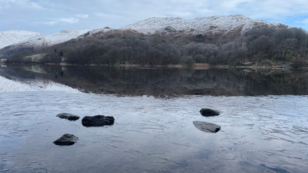
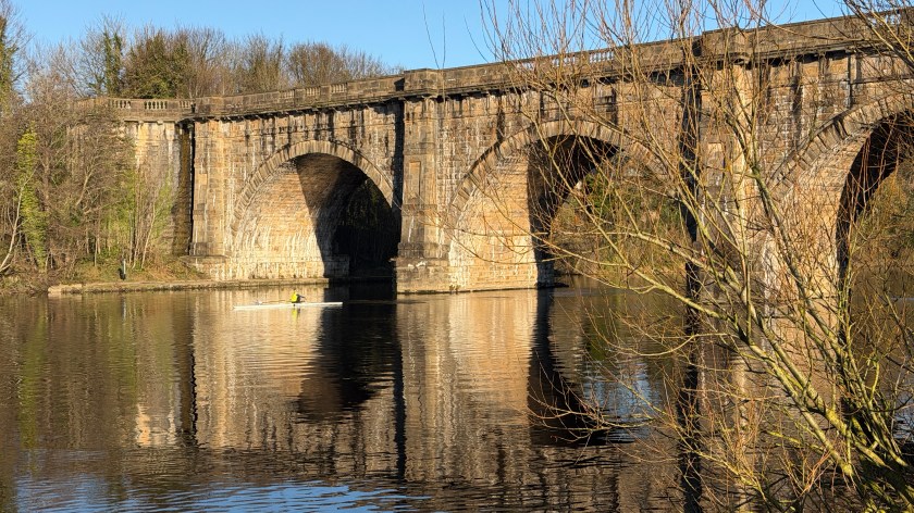
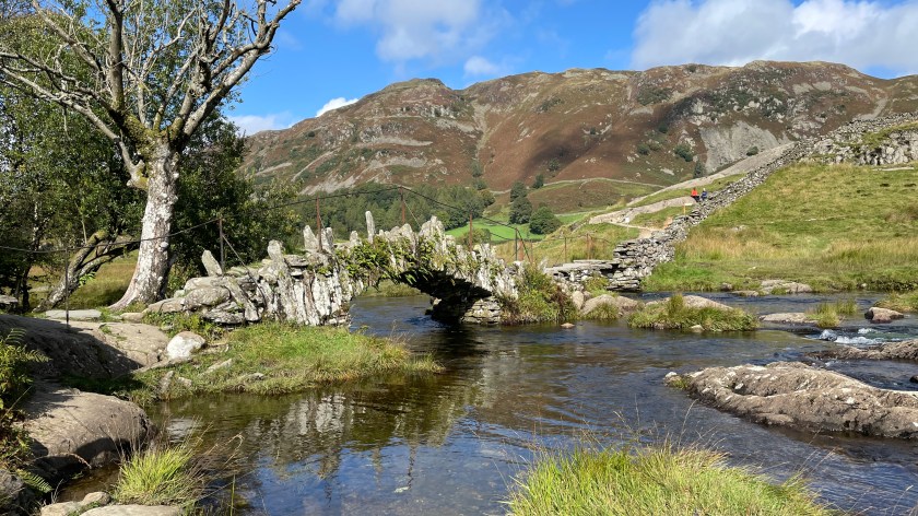
The first part of this walk takes us along the former quarry tracks up to Rydal Cave. Simply head up the road that you’ve just driven on to get to the car park and carry on once you get to the gate at the end. Just after the gate you’ll get your first view across Rydal Water (the header image). You may, at this point, start to feel something poetic building inside you, if you do you wouldn’t be the first. The village of Rydal was the favourite home of the acclaimed poet William Wordsworth, his family, and his sister Dorothy, who deserves far more acclaim than she receives.

Dorothy Wordsworth’s Journals, many written in Rydal and Grasmere, are wonderfully poetic:

After tea we rowed down to Loughrigg Fell, visited the white foxglove, gathered wild strawberries, and walked up to view Rydale. We lay a long time looking at the lake; the shores all dim with the scorching sun. The ferns were turning yellow, that is, here and there one was quite turned. We walked round by Benson’s wood home. The lake was now most still, and reflected the beautiful yellow and blue and purple and grey colours of the sky.

Dorothy Wordsworth

(I don’t know when Rydale became Rydal, other than to note it was at some point after the early 1800s which is when Dorothy was writing.)

You’ll see from this vantage point that there is a path running alongside the lake, we are coming back that way, for now we are going to head up to Rydal Caves keeping left on the higher path.

There is one very famous cave directly on this route which you can go into with ease, but before that there are a few smaller caves which are more challenging to get into. One of the smaller caves used to have a drum kit inside it which sounded amazing. It’s been a while since I’ve been in that cave, as it now requires a rope to get in, so can’t confirm whether the drum kit is still there.

These caves are the result of slate mining and as you work your way along this lane and into the vast cathedral space it is worth remembering that this was a place of noisy, dusty, dangerous toil.

The Lake District is littered with various mines and quarries, the area wouldn’t be the same without them. This is a land shaped by people.

Having stepped inside the large cave and taken in the view and the acoustics, it’s time to carry on along the side of Rydal Water towards Grasmere. I love the views of Nab Scar towering over the diminutive Rydal Water from this elevated position.

As you near the end of Rydal Water there is a fork in the path where you should continue to take the higher option. This path will take you around the corner onto Loughrigg Terrace with elevated views across Grasmere including Helm Crag (also known as the Lion and the Lamb) and Dunmail Riase (remembering the last king of Cumbria who is reportedly buried below the cairn near to the top).

Carry on along Loughrigg Terrace to the end and into the woods. You need to go through one gate at the end of the path and then a slight right through another gate into Red Bank Wood. This is a gentle walk through established trees marking the seasons by their attire.

Eventually you’ll reach a cottage next to the road between Grasmere and Loughrigg Tarn. At the entrance to the driveway for the cottage there is a path to the right which cuts back through the woods heading downhill and on to the lakeside path below Loughrigg Terrace. The beach here is a great place for a swim but can get a bit crowded.

On leaving the beach you’ll come to a wooden footbridge across the stream. You have a choice here, the route I’ve provided takes you along the southern edge of the stream this path can be flooded when the river is high, but rarely. It can also be a bit uneven. If you prefer something a bit more even, you can cross the bridge take a right hand turn on the other side and follow the path along the other side of the river. Both paths meet at a metal bridge.

The metal bridge is where you’d join the route if you’ve parked at either White Moss or Rydal Water car parks.

From the metal bridge head through the woods up the hill until you reach a gate. Through the gate turn left and along the path by the wall. You should be able to see Rydal Water ahead of you. Walk along this path all the way to the other end of the lake. There are several places to swim along this part of the route, it’s also a great place to practice your skimming, there are plenty of flat stones available.

As you near the end of the lake you’ll notice the gate that you came through on your way to the cave higher up on your right. We are going to go through the lower gate. This route takes you through some more woods and along the river where you’ll get views of the boathouse which is a classic Lake District photo opportunity. Soon you’ll come to a footbridge, don’t go over the bridge but head right and up the hill through some woods and onto the car park road. You’ll reach the car park road via a small gate; the car park is down the hill to your left.

There are several variations to this walk:

As hinted a couple of times you can start this route from White Moss Carp Park or Rydal Water Car Park. There are a few reasons why you may choose to do this, the first being parking. The second is access to a toilet which can be found in the woods between White Moss and Rydal Water car parks. The third reason being access to refreshments; there is normally a pop-up coffee van by the side of the stream near to the toilets.

You can extend the walk a bit near the end. Instead of turning right up onto the car park road you can turn left across the footbridge, from there you can cross the road into the village. In the village there are several places of interest.

Almost directly opposite the exit from the footbridge is Dora’s Field which is full of daffodils in the spring. The daffodils were planted as a memorial to one of the Wordsworth’s daughters who died aged 43 of tuberculosis. Dora’s Field has a gate into the church grounds, both the grounds and the church are lovely with even more Wordsworth associations. Up the hill from the church is Rydal Mount where the Wordsworth family lived for a while.

As you go up the hill, before Rydal Mount there is an entrance to the ground of Rydal Hall. The hall is a Christian retreat, but the grounds are open to the public where there are several walks and gardens to explore. Within the ground is one of the Lake District’s most photographed waterfalls with The Grot alongside it. The Grot is a great place to spend some time in quiet. Swimming is not permitted in the waterfall.

Within the grounds of Rydal Hall is the Old School Room Tea Shop which we’ve visited several times and always had great food, but haven’t visited for a while and hence it’s not currently included in Graham’s Cafes.

There are a couple of Graham’s Cafe’s nearby, last time we did this walk we ventured to Lucia’s Coffee + Bakehouse in Grasmere.

Another option on this walk is to follow the Coffin Trail along the other shore back to your car, I’m going to cover that route as a whole new guide.

The view across Rydal Water towards Grasmere
Inside the cave
Inside the cave
The view from the start of Loughrigg Terrace towards Grasmere Village
The view across Grasmere towards Dunmail Raise
A frozen Rydal Water towards Nab Scar
The Daffodils of Dora’s Field

Rossall Beach Promenade | Graham’s Guides

Is there anything quite like a walk along a windy beach?

Graham’s Walks📌
Distance5.2 miles
DifficultyEasy
OS Maps Route🗺️
GPX📁

Here in the UK we like a seaside promenade on a sunny day, taking in the blue skies and sea.

However, the British weather is never guaranteed, which means we are conditioned to be just as happy walking along a windy promenade on a cloudy day with the white capped waves careering into the sands. It was precisely these conditions that greeted me as I parked in the promenade car park at Rossall Beach on a recent Sunday afternoon.

There are several places to walk along the Fylde coast each with their own charms. The charm of Rossall Beach is that it’s a quiet sandy beach where you get great views across to Morecambe Bay to the Lake District and even as far as the Isle of Man. If you want fish-and-chip shops, ice-cream parlours and amusement arcades you need to be a few miles further south. Rossall Beach is more rural, although also, almost suburban.

From the Rossall Beach promenade car park I head north along the beach taking in the changing skies and relishing in the occasional burst of sunshine sparkling off the Irish Sea. I’m conscious that the wind is on my back and that, at some point, I am going to need to turn around and walk directly into it. The tide is on its way out and there’s ample firm sand to walk on. It’s a shorts and jumpers day.

I’ve set myself the target of getting to the Rossall Point Observation Tower, to give it it’s Sunday name, about 2.5 miles (about 4 km) away. This rather strange structure has various uses including a public observatory. There are also public toilets here.

Part way along I pass Rossall School a place of education since 1844. The buildings are from a different time to everything that surrounds them making it look strangely out of place even though it was here first.

The weather continues to change as I enjoy the scenery, there are a few other people around, but this isn’t a day where the beach is full. I don’t think I’ve ever seen the beach flooded with people here, that’s part of the joy of the place it’s easy to get to but it also feels isolated.

Having reached the tower it’s time to head back facing into the strengthening wind. It looks like the weather may turn to rain so I choose the promenade for my return. There has been lots of work on the sea defenses in recent years including the integration of paths, boulder groins, various seating options and art installations. There’s also areas set aside for nature on the onshore side of the defences forming the Larkholme Grasslands. I particularly like the Sea Swallow sculptures forming part of the Mythic Coast project.

This is a great place for a sunset, not that there is going to be one on this particular day the cloud is thickening fast.

I’m passed by various joggers and cyclists many of whom have the look of people rapidly heading for a safe haven. One young man passes me in short-shorts and a vest top, muscles pumped. He’s in fully Rocky mode punching away at some invisible opponent. He stops not far in-front of me and proceeds to go through a routine of upper-cuts, hooks and jabs, then continues his run. He’s carrying a portable speaker that’s proving musical accompaniment.

Having returned to the car park I look at the houses with views of the sea, that also overlooking the expanse of cars. There are always at least one of them for sale and it’s become obligatory to look them up on Rightmove. Views of the Irish Sea come at a premium.

There are a few variations you can make to this walk.

If you start the walk a bit further south at Jubilee Gardens you can visit the Sea Ogre and take pictures of Mary’s Shell. If you are a Star Wars fan you can stand in part of the set at FBKafe which featured in the Andor spin-off.

At the far end of the walk you can choose to walk a bit further and take in the events at the boating lake.

Part way back from the observation tower, you can choose to head inland and make your way via the Larkholme Grasslands. This can make for a less windy return.

You can, also, make the walk to the Observation Tower much shorter by starting at the Rossall Point car park heading south.

Header Image: This is the view of the observation tower from the beach.