Skeggles Water Circular including Cocklaw Fell and Hollow Moor | Birkett KEN 2 | Graham’s Guides

Get away from the crowds and explore some less visited fells and the gloriously names Skeggles Water.

Graham’s Walks📌
Distance5.6 miles/9 km
Elevation1182 ft/360 m
DifficultyDifficult
Map🗺
GPX📁
Graham’s CafeYou will drive past More? The Artisan Baker
ClassificationBirketts KEN 2

The Area

I must admit that until I was reading though Bill Birkett’s “Complete Lakeland Walks” I’d never heard of Skeggles Water. I say that as someone who has walked most areas of Cumbria and completed a round of the Wainwright fells. My lack of knowledge is a reflection of how little attention is given to the areas at the edge of the Lake District and the draw of the big peaks. It’s not surprising that people go for the larger fells and the more dramatic lakes but in doing so they miss the opportunity for a quieter day.

Skeggles Water sits in the hills between the valleys of Kentmere and Longsleddale. There’s no obvious origin to the name Skeggles; it was likely the name of someone from the Norse era who had the nickname Skeggi (beardy). Both valleys have long histories of settlement with evidence of Neolithic and Bronze Age activity (2,000 to 4,000 BC), the Romans used the nearby High Street as a route between their forts (100 to 400 AD) and there’s a Norse heritage in many of the place names.

We don’t really have strict rules for the way that we name things in English even though some people think we do. Kentmere suggests a mere (lake or pond) from the river Kent. However, it’s the valley and village that have become known as Kentmere and the mere is is known as Kentmere Tarn, further up the valley is Kentmere Reservoir. Confused?

Most of this walk is across an area of Kentmere known as Green Quarter. In more feudal times the grazing around Kentmere village was separated into four areas with the village church at the centre. Each grazing area had an allowance of tenants, each tenant had an allocation of cattle. In 1760 each quarter had 15 tenants, each tenants was allowed to graze 10 cattle. Green Quarter appears to be the only one of the quarters still visible on the map.

The Walk

The route of this walk isn’t on all, or even most, maps. The first third is on a well defined bridleway; the second third takes a path around the tarn and up onto the fells, most of it looks like it is regularly travelled by a quad-bike but can be tricky to stick to as it’s not on many of the maps; the final third is back onto well defined bridleways. The navigational challenges are why I’ve marked it as Difficult.

This walk starts from the village where there is very limited parking outside the Kentmere Institute for a donation. For most people this is also the start of the Kentmere Horseshoe a popular walk that contains numerous Wainwrights. In the summer there is also a car park in a field just before you enter the village. Away from these two parking areas there are very few areas to park and the roads are narrow. Don’t be that person who causes havoc for everyone else.

From the Institute head back along Hollingrigg Lane past the church and across the river; then turn left up Hellwell Lane.

Part way along Hellwell Lane you’ll see a footpath fingerpost on the right and a small gate up some steps which has the nameplate Lucy’s Wood. The path goes pretty much straight up to another gate onto a farm lane which will bring you out onto Lowfield Lane. Turning left and up the hill a short way. There’s a bridleway on the right through a farm gate; this is Cornclose Lane.

The route follows the bridleway for a little while until there’s a fork where we take the left hand option, the righthand route is marked as private. The path steadily ascends along the edge of the hill sweeping to the left.

The path reaches an apex from which it descends into a shallow valley and you will soon be able to see Skeggles Water in the middle. Just off the path before you reach the water there is a barn ruin; just beyond it is a path leading to the southern edge of the lake through a gap in a drystone wall.

Keep on the path around the southern end of the water and you’ll come to a footbridge across the outflow stream. Continue around, taking in the views until the path meets a more defined path heading north-westerly. Many of the maps only have a path as far as the footbridge but the path beyond is reasonably clear. At one point the path takes a detour away from the lake to find a gate through a fence.

Along this path you can see Cocklaw Fell rising steadily to the right. You are looking for a path to the right heading pretty much straight up to the top of the fell. This path probably isn’t on your map and isn’t easy to find on the ground; sometimes you just need to set a baring and follow it. The summit of Cocklaw Fell is little more than a hillock and you may need to take a baring to convince yourself you are really at the top. The views over into Longsleddale open out at this point.

From the small summit of Cocklaw Fell you should be able to see a fence just below it to the north-west. Turn left at the fence and follow it along and down to the main track and to a point where a couple of paths meet at the intersection of a couple of fences. At this point there is a path that heads up towards the summit of Hollow Moor off the main track to the right. This path, again, looks like it’s regularly travelled by a quad-bike but it isn’t on the normal OS topographic maps, but is on the OSMaps app standard view and OpenStreetMaps variants like CoMaps.

This path opens out the views towards upper Kentmere and the fells beyond, climbing steadily until you reach the summit of Hollow Moor. Near the summit of Hollow Moor it’s worth taking a few steps towards the valley to get the best views. Near to the top there is a stone that used to part of fence. According to the various maps this isn’t the summit, but it’s near enough to mark it.

The path off the summit is a continuation of the path you came up on. This will take you down the side of the fell towards another bridleway that crosses Kill Gill and into Kentmere. There are a couple of routes through Kentmere, the simplest is to take the path along the side of the stream onto Hellwell Lane. Turn left on the lane back to the bridge across the Kent and up to the church, the institute and your transport.

The church is often open and is lovely inside. There’s a also a really good local history and natural history display.

Alternatives and Extensions

There are probably simpler ways of ticking off Cocklaw Fell and Hollow Moor if you are trying to fit your Birketts list but this isn’t an arduous walk as it is. Perhaps you could miss out the circumnavigation of Skeggles Water but that feels like you’d be missing out on many of the best views. You could also do the fells from Longsleddale but it would be difficult to make it a circular route.

Crossing the Kent in the village
The steps up to Lucy’s wood
Walking the bridleway
The view back to the village and Sallows beyond
First glimpses of Skeggles Water
The barn ruin and the path to the lake
First views by Skeggles Water
Skeggles Water
The gate part way around Skeggles Water
The path along the fence after Cocklaw Fell
View of Hollow Moor
Views of Upper Kentmere
The fence post near the summit of Hollow Moor
Follow the track down from the summit of Hollow Moor
The view back to the church
Kentmere church
The summer car park

Tarn Hows Circular via Tom Gill from Glen Mary Bridge | Graham’s Guides

A beautiful walk when you don’t want to be out too long.

Graham’s Walks📌
Distance2.6 miles
DifficultyModerate
Map🗺
GPX📁
Graham’s CafeNot on this one.

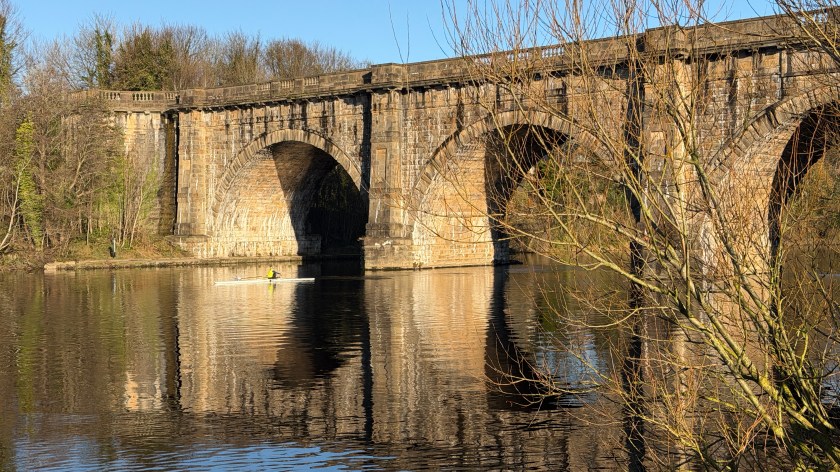
Tarn Hows is a popular destination. If you want a walk where you don’t see anyone, this is not the place. This popularity isn’t anything new, Charabanc would travel up from Ambleside and Windermere in the 1890s. That said, I’ve never known the tarn to be over-run with people; there’s plenty of space to spread out and there’s probably less public transport now than there was in the days of the charabanc.

The walk starts from the Glen Mary Bridge car park, a name that was given to the local area by John Ruskin who thought that the name Tom Gill wasn’t picturesque enough. It is a picturesque. It’s a National Trust car park making it free for members. Much of the land around here is owned and operated by the National Trust including the tarn itself, I’ll talk a bit more about that later.

(It’s worth noting here that a “gill” is a local Cumbrian name for a valley with a stream in it, with Scandinavian roots. A “glen” is a Scottish name for the same thing.)

If Glen Mary car park is full, which it can do, there are a few other parking spaces just off the main road alongside Yew Tree Tarn from where you can also begin this dainty walk.

This is a walk of two halves. The first part takes you rambling up through an ancient wood alongside a cascading stream, it’s not hard but it is uneven in places. The second part is around the tarn which is more like a promenade than a ramble. The main path around the tarn is flat, wide and well paved.

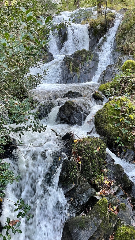
From the car park there’s a footbridge across the stream which is your guide to the tarn. There aren’t any decisions to make on this route, you follow the well worn path on the ground which follows the general route of the stream. There are several delightful waterfalls on your way up the hill, some you explore via short detours.

Part way up the hill, through a small gate, the cutting narrows significantly, the walking gets a bit more tricky, you’ll struggle to get lost though.

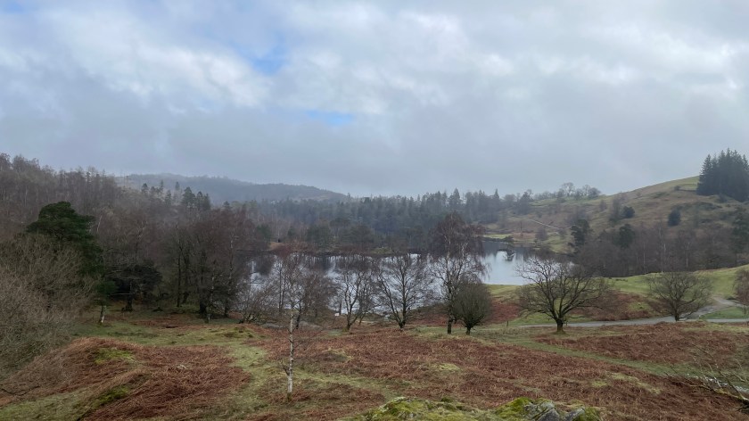
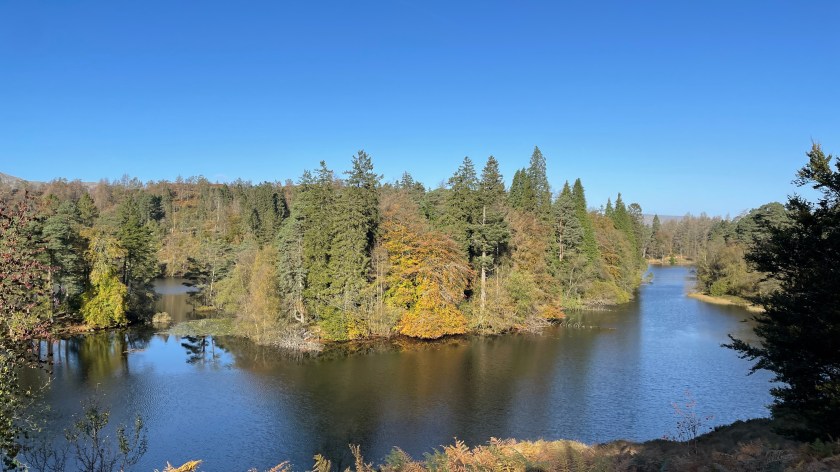
The stream takes you to the tarn where it flows out via a small dam. There used to be three small tarns in this area, the dam raised the water level to join them together into the larger expanse of water we see today. Much of what people assume is natural in the Lake District has been tinkered with by humans.

The tarn is banded by a circular route which brings you back to the dam. On your way around there are several places to drift off the main path to see something of interest, or get a better view. This is a great place to let children explore, there are still plenty of trees to climb even though the area has been heavily impacted by storms over recent years.

The promenade is very picturesque with photo opportunities around many of the corners.

It’s traditional for us to go clockwise around the tarn, so we head left, but could just as easily head right. The end of the tarn is marked by a bridge which is accompanied by a seat with glorious views along the full length of the tarn.

Having promenaded down one side it’s time to do the same along the other.

At the other end of the tarn there’s another car park operated by the National Trust, you could use this as a start to the walk, but where’s the fun in that. There are some toilets at the car park, if you are fortunate there will also be an ice-cream van.

From the ice-cream van head back down to the dam and onto the path back to Glen Mary Bridge.

On the other side of the road from Glen Mary Bridge is Yew Tree Farm which is notable for several reasons. The farm is part of an estate of land known as Monk Coniston which stretches all the way down to the shores of Coniston, and included Tarn Hows. When this land was put up for sale in 1930 a local couple Mr and Mrs Heelis, him a solicitor, her an author and illustrator who is better known as Beatrix Potter, purchased it. They were determined that the estate shouldn’t be broken up or developed. The National Trust wasn’t the large organisation it is today and weren’t in a position to buy the land. Beatrix later donated the land to the National Trust, but with a stipulation, the local Herdwick sheep were to continue on the land, each farm being allocated a minimum headcount.

The Herdwick allocation probably saved the breed from extinction in this area of the Lake District, but it hasn’t always been easy, the wool is course and they develop slowly so you can’t use the lamb meat. In recent years, however, the farmers at Yew Tree farm have found a way of making the Herdwick profitable and now have over 1,000. Sue and I recently spent a wonderful day at the farm on a Herdwick Experience where they tell you about the history of the sheep, about the resulting hogget which is used in several Michelin Starred restaurants in the area and can be purchased from the farm. They also, as part of the experience, take you to meet a group of the sheep who like to be petted. You sit in a field and they join you, sitting alongside you as you scratch their backs.

(A lamb is a sheep that is less than a year old, a hogget is a step between one and two years.)

Oh, yes, also, Yew Tree Farm is one of the main locations for the ‘Miss Potter’ film with Rene Zellwigger and Ewan McGregor.

What about variations?

There aren’t many options for variant walks through the woods along the stream, you can sometimes venture closer to the stream, but that’s about it.

Once you get to Tarn Hows there are a few more options to add in extra distance and difficulty. Near the beginning you can head off to Tom Heights from which there are good views of the surrounding hills (it’s been a few years since I’ve been up there so I’m hoping the views are still there). You can join the Tom Heights path on to the walk up to Black Fell. Black Fell is one of the smaller, and easier, Wainwrights, so you can get an easy tick.

Another route up to Black Fell is from a stile at the end of the Tarn via the Iron Keld Plantation. The path to Iron Keld Plantation can also be used to access a route that circles the tarn from higher up. The higher route gives better views of the surrounding hills and is less well travelled.

From the car park at Tarn Hows there’s a different route back to Glen Mary Bridge, I’ve never walked it so can’t comment.

Glen Mary
Tom Gill Waterfall
Tarn Hows
Tarn Hows near to the car park
Yew Tree Farm
One of the friendly Herdwicks

Loughrigg Tarn Circular from Skelwith Bridge | Graham’s Guides

A wonderful walk, fabulous views and one of the best outdoor swim spots in the country.

Graham’s Walks📌
Distance2.5 miles
DifficultyModerate
Map🗺
GPX📁
Graham’s CafeChesters by the River

I like to plan walks with a reward half-way around, in today’s walk that reward is the opportunity to swim in a beautiful tranquil tarn.

We start this walk in Skelwith Bridge. If you can, park on the Langdale road (B5343) near to the Skelwith Bridge Hotel. There’s also the option of using the car park another 0.4 mile further up the road or some spaces in the ground of the old slate-works. Don’t park in the hotel car park, or in the Chesters by the River car park.

This is one of those walks where to get a parking space you have to understand the rhythm of tourism in the Lake District. If you arrive on a sunny day in the middle of the morning through to the middle of the afternoon you aren’t likely to be able to park, especially if it’s a school holiday or a weekend. You may be fortunate, but you can’t rely upon it. Arrive earlier, or later, than that and you’ll have a much better chance of getting parked, these are also the times with the best light and hence the best views.

For us this is either an early morning walk with lunch back at Chesters by the River, or it’s an afternoon, into the evening, walk with a picnic tea.

We normally take our time on this walk, it’s a tramp, it’s not a route-march.

Opposite the Skelwith Bridge Hotel is a kissing gate with an easily identifiable path up the hill to another gate. Here the path is more narrow and uneven, it’s only for a short distance but is the reason I mark this route as Moderate. There’s something soothing about walking in the dappled light of a wood especially when the birds are singing.

Soon you’ll come out into the Neaum Crag holiday park where the route through is reasonably well marked. You are heading straight across, past the pool and up the hill which veers to the left. This is where, in the winter, this walk can get a bit icy.

At the top of the hill there’s another gate out into open countryside. Soon you’ll be rewarded with views of Loughrigg Fell and the Langdales in the distance followed shortly afterwards by views of the tarn. In the spring you’ll be greeted by Bluebells, in the summer by Bracken. The path traverses a bank, downwards towards the road past a quintessentially Lake District farm at Loughrigg Fold.

Once you’ve reached the road follow it to the left for a short distance before you arrive at a stile on the right. The path around the lake is quite clear here, across the field, through another gate, across another field right alongside the tarn.

If you are planning to swim there are numerous options here, some have shade, some in the open. The further round you go the better your view across the tarn and back towards the Langdales. These views are particularly magical at sunset. A favourite swimming spot for many is marked by a lone tree that bends out over the tarn.

In the spring and early summer, Cuckoos and Woodpecker can often be heard in the woods nearby. The Waterlillies are gorgeous in the summer and so is the cruely named Bogbean.

Fortunately, this place of beauty is remote enough to avoid being overcrowded. We’ve never been when it has resembled the more popular tourist locations just a few miles down the road. There are often a few other groups, but each of them respecting the tranquillity of the place.

Please note that you aren’t allowed to take craft or inflatables onto the tarn, this isn’t Bowness.

Once you’ve finished your swim, picnic, yoga, contemplations, or whether it is you do in such a place, continue on the path towards a small gate in the fence by the lane. Through the gate turn right. Take the lane around to the road, and then the road back to Loughrigg Fold. The road is generally quiet, but please remember, you are sharing the space with vehicles.

From Loughrigg Fold retrace your route up the lane, into Neaum Cragg Holiday Park and eventually back down to your vehicle.

There are some variations on this walk:

If you have parked in the car park below Neaum Crag, you can take a different path up and over to the tarn. This path brings you down to Loughrigg Fold from where the route is the same as above. Alternatively, you can cross the road and down onto the Elterwater path. If you take a left you can follow the river down towards the waterfalls at Skelwith Force and into the slate-works, from where you can join the path as described. The waterfalls are worth a visit at any time, but especially if the river is high.

If you just want do a circuit of the tarn without all the uphill and downhill bits there are a few car parking spaces just at the point beyond Loughrigg Fold where the path crosses the field. There are only a few and please park sensibly.

You could also extend your walk just a very small amount by incorporating a visit to Chesters by the River, a long time Lake District favourite.

You could massively extend the walk by adding in a trip to the top of Loughrigg Fell but that would make it a completely different walk with a different name.

Header Image: Loughrigg Tarn looking up toward Loughrigg Fell.

Loughrigg Tarn
Loughrigg Tarn
Loughrigg Fell from Loughrigg Tarn
Loughrigg Tarn