
| Graham’s Walks | 📌 |
|---|---|
| Distance | 3.2 miles |
| Difficulty | Moderate |
| Map | 🗺️ |
| GPX | 📁 |
| Graham’s Cafe | Levens Kitchen |
The Area
Levens Deer Park is part of the grounds of Levens Hall, it is free to enter. Parking for free at Levens Hall as is use of the toilets. Then on top of that, you can go to Levens Kitchen at either the beginning or the end of the walk, or both if that’s how the mood takes you.
What’s not to like, parking, toilets, walk and cafe all for the cost of a coffee. You could even pick up some fresh bread and cakes at the bakery.
While we love the Lake District there are days when we would rather be a little closer to home and away from the visiting hoards; this walk is one of our favourites on such occasions. That’s not to say that this is a second-best walk, it’s a wonderful little ramble. It’s not overly long and not too arduous, but is long enough to get the lungs going with enough elevation to stretch the legs. There’s plenty of interest too; waterfalls, goats, deer and if you are fortunate jumping salmon.
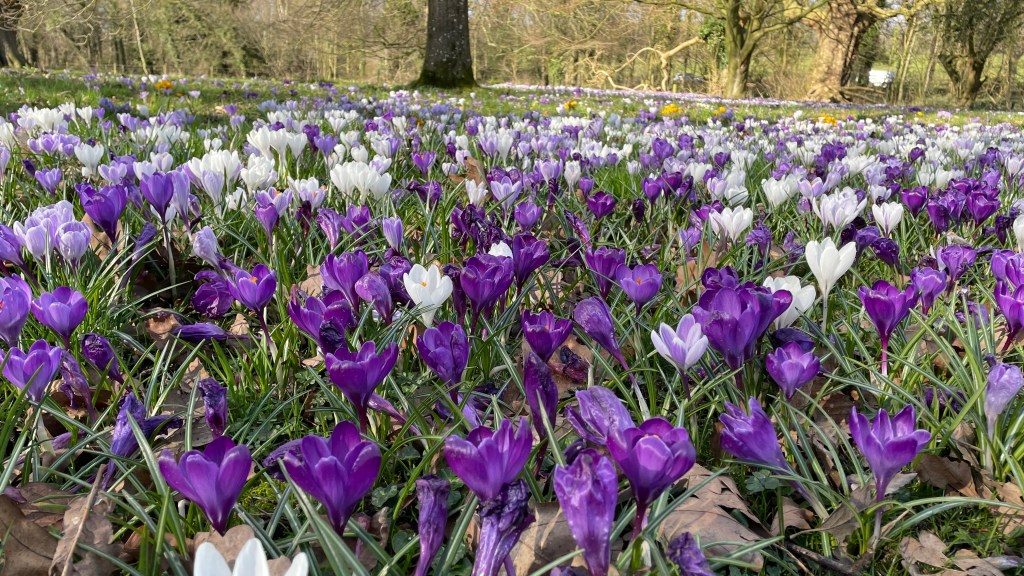
This walk is good all year round. In the spring there are blankets of crocus alongside the river near to the car park and blankets of snowdrops in other places. The summer brings cooling dappled light along deciduous tree lined avenues. In the autumn the trees transform into an explosion of colour giving great views along the river, this is when the salmon do their leaping. Cold crisp days in the winter bring a different light and the joy of crunching through parkland.
While the parkland may look naturalistic, it was actually landscaped over 300 years ago at the same time as the gardens at the hall. Imagine the physical manpower involved in landscaping such a vast area 300 years ago!
The Walk
There are a few places on this route where a decision needs to be made, most of the time the route is defined by the parkland. At the farthest end of the walk you leave the park to cross the river and then reenter it to return.
We start this walk from the car park of Levens Hall. It’s free to park and I’ve never known parking to be a problem. If the car park is closed for any reason there is also parking on the road leading down from the A590. Not really sure how to describe this parking option, so here’s a pin for it.
Head out of the hall the way you came in, along the avenue through the stone archway. You will need your wits about you as you cross the road; the cars can come fast and there isn’t an obvious place to safely cross.
Once on the other side of the road we are going to do this walk clockwise which means walking along the road for a short distance, across the river and into the park through the small steel gates in the wall and then down some steps onto the path.
You should now be able to see in front of you the river Kent to your right as it sweeps to the left. The path follows this same sweep up a gradual incline. There’s also a signpost showing the walk. This sign also, currently, advises you not to swim in the river because of pollution, it always looks clear, but the danger is often what you can’t see.
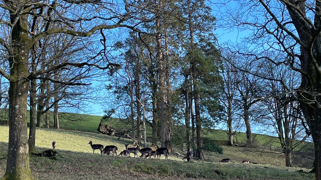
If you are fortunate you may see some black fallow deer or some Bagot goats. The deer are regularly on this side of the river, but the goats are more regularly on the other side near to the end of the walk. The black fallow deer are a dark variant of the common European fallow deer. The Bagot goats have striking horns and very cute kids in the spring.
We follow this path across the park and upstream. The path is well defined and eventually takes a lefthand turn reaching a stile and gate over a wall. On the far side of the wall turn right and follow the wall along the edge of the field. This is one area where it can get muddy in wet periods.
The path follows the wall across a field, over another stile, and across the middle of another field.
On the far side of the second field a gate opens out on to a lane by a cottage. Turn right and follow the lane until you come to a path underneath the A590 as it travels over the River Kent. The lane continues on the other side.
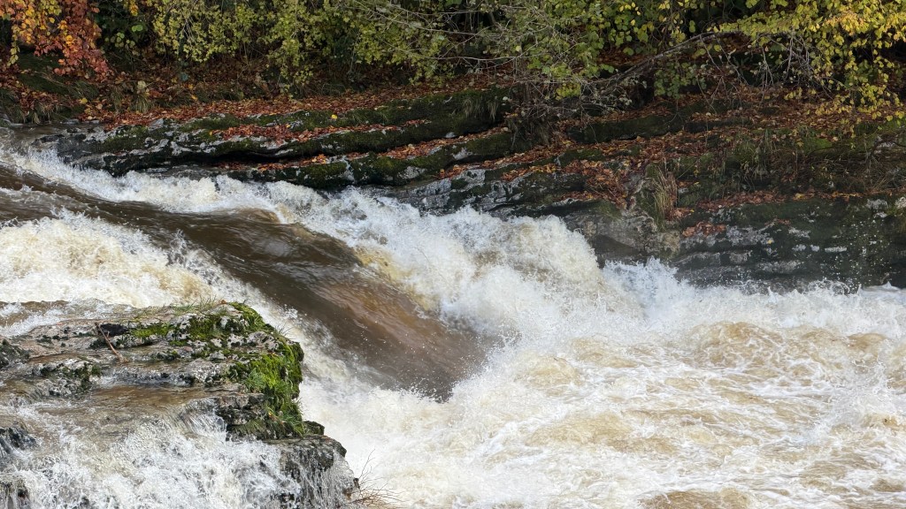
A short way along the lane you will come to some cottages. Just before these cottages there’s a small carpark. To the rear of the carpark there’s a waterfall where, in the right season and if you wait long enough, you can see salmon leaping.
Continuing along the lane you will get views of several other waterfalls. This area is abundant with snowdrops in the spring.
The lane comes out at a road-bridge over the river to the right. Walk across the bridge and take the road to the right on the other side. It’s mostly righthand turns on this walk – it’s a clockwise walk. The views aren’t great for this small section as the river is masked by a large stone wall.
Follow the road over the A590 dual carriageway beyond which you will see a gate to the right. There’s a stile with a small gate at the top over which you will turn left. You are now back in the deer park on an avenue of mature deciduous trees. You follow this avenue most of the way back to the hall.
I imagine that the owners of the hall would promenade along this avenue with all the trappings of the important, or hunt the deer on horseback.
Near to the end of the avenue the path veers off to the right following the route of the river back to the road. This is the area where the Bagot goats tend to frequent.
Cross the road back to the hall and your vehicle.
Alternatives and Variations
There’s an extension to the route at the far end that takes in the now disused upper-reaches of the Lancaster Canal and also takes in Sedgwick House and the Hincaster Tunnel. This extension is fully described as Walk 3 on the Lancaster Canal Towpath Trail.
At the top of the walk, before crossing over the River Kent there’s a short extension to a footbridge a bit further upstream beyond the wonderfully named Nannypie Lane. I’ve seen photographs of salmon leaping in this area, but never seen any myself.