Food with a fabulous view across the Lake District.
Graham’s Guidelines
* Rating (1 to 5)
Coffee
N/A
Food
5*
Conversation
5*
People Watching
4*
On a recent bank holiday Sue and I decided to revisit one of our favourite walks, incorporate a swim and do it all before lunch. Sue even managed a trip to the gym before we set off.
One of the advantages of being close to the Lake District is that you can get into some of the more popular spots before everyone arrives and out again before they decide to leave. Despite our early start we only just managed to stick to our plans, squeezing into the last parking space in Pelter Bridge Car Park at the southern end of Rydal.
There was an interesting encounter in the car park, but I’ll write about that in a different post.
Having completed our 4.3 mile moderate walk and swum between the islands we were ready for food.
There are several good cafe options in this area but on a bank holiday you want somewhere a little away from the tourist honeypots. It was with this in mind that we chose to make a return visit to Force Cafe and Terrace.
We’d been before, only for coffee and cake, it was alright, but not great. That was not long after the launch and sometimes it takes a place time to find the right staff and bed in.
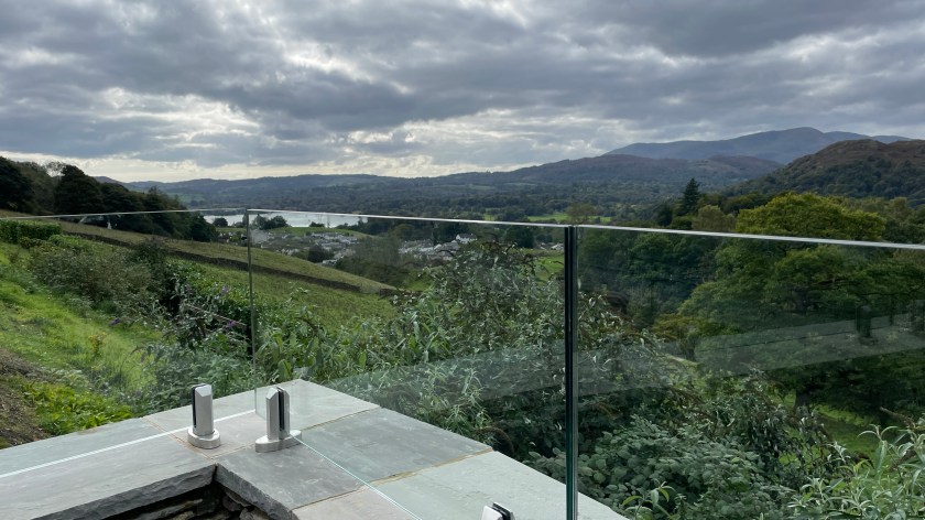
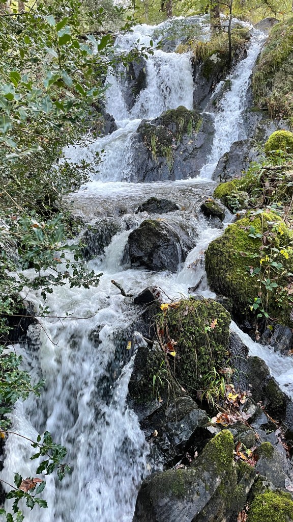
Last time we visited was on our way down from Wansfell Pike having parked in Ambleside. This time, having already done our exercise, we drove up. The road is quite steep running alongside Stock Ghyll which contains a set of waterfalls, worth a visit most of the time, especially when it’s been raining, which it hasn’t done for weeks.
There is plenty of parking at Force, but it’s time limited, don’t expect to leave your vehicle there all day.
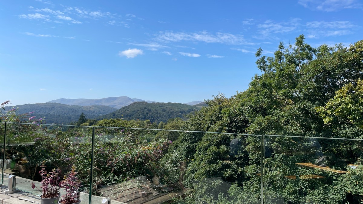
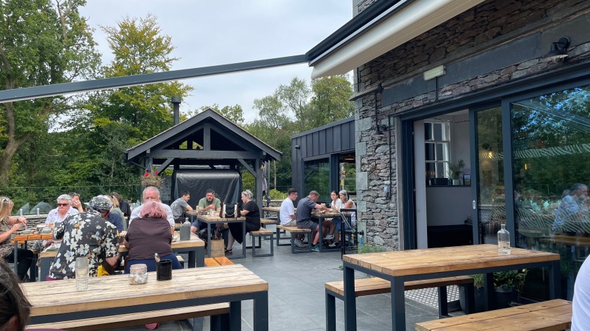
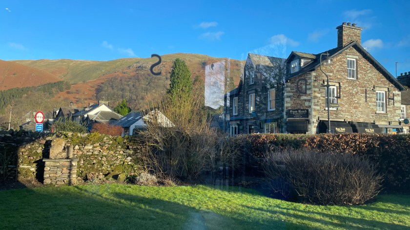
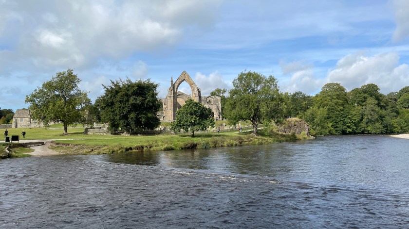
While the inside of the cafe at Force is lovely, the real showstopper is the terrace. I’m not saying that visiting on a good-weather day is mandatory, but if you do, you are in for a treat. On this occasion we struck the jackpot, clear skies with glorious views across the Lake District fells to the west with Coniston Old Man standing majestically in the distance.
There was plenty of people watching to do on the terrace. Several foreign languages and accents, definitely French, others Eastern European and some Asian. There were young people who were barely starting their day, others like us, a little older who had been awake a while. Many dressed for the hills, a few who were more country casual. From the body language everyone commenting on the scenery.
Lunch comprised Apple and Celeriac Soup and Eggs Benedict Rosti with extra bacon. Both were excellent, and so were the soft drinks that we chose for accompaniment. Lots of people were tricking into the breakfast, brunch, options.
The menu at Force is quite limited which you might regard as a challenge; for me a limited menu tends to indicate somewhere that cares about its food.
The service was good, despite the business of the day. We even got into a conversation with one of the ladies serving regarding the various places available for a swim. Neither of us had anywhere new to share in the Lake District, but it was good to find a kindred spirit.
While we love the Lake District, we are privileged to be surrounded by many beautiful places a bit closer to home. Silverdale is somewhere we have visited regularly even spending holiday weeks. A frequent route for us is a circular walk from Wolfhouse through Scout Wood, across the village to The Cove and back to the car and a cafe stop.
On a recent visit our walk was tinged with sadness; one of our favourite cafes, the one at Wolfhouse itself, had closed a few months before. We have many fond memories of sitting in the tiny cafe, or the outside courtyard having rented the house next to the gallery a coupe of times..
Silverdale sits on limestone which makes this countryside what it is, showing up in outcrops, forming the cliffs and in the miles of drystone walls. While we are reflecting on Silverdale, it’s worth noting that it’s probably not called Silverdale because of the colour or even the metal, it’s far more likely to be a morphing of a Norse word. There are quite a lot of things around the Irish Sea that were named by the Vikings.
The Walk
On the map this walk starts from Wolfhouse itself, but on our latest visit we set off from the entrance to Scout Wood which is a little way up the hill from Wolfhouse. There’s room for a few cars there; it’s also a great place to start one of the alternatives to this walk which adds in Jenny Brown’s Point. The entrance to Scout Wood is through a gap in the limestone wall immediately followed by a fork of the path, we take the one to the right, the higher road.
This portion of the walk takes us along the top of a limestone cliff covered in ancient woodland on one side, with pastureland, over the drystone wall, on the other. The cliff is known as Woodwell Cliff reflecting the presence of the Woodwell at the bottom. There is another route around Silverdale that takes in the various ancient wells in the area but that’s not what we have planned for today.
This is sheep country, they are likely to be in the fields on at least part of this walk; this also means that it’s a great walk in the spring when the lambs have been born.
We follow the path along the top of the cliff and through the woods. At the end of the woods is a kissing-gate where the woods opens out. The path takes a bit of a wiggle here to the right and then to the left where there’s another gate following which the route is again defined by the cliff, a wall and some more pastureland.
At the end of the wall there’s a gap to the right onto a path alongside a field and onto a lane known as The Chase.
We are at the outskirts of the village here and about to meet Stankelt Road. At the end of The Chase turn right and then the next left down a lane. At the end of the is a farmhouse and to the left of it is a gate into a field. The path here runs along the back of some houses to the left and opens out to a wonderful view across the open countryside to the right. If you know what you are looking for you can see the outline of the huge Middlebarrow Quarry now disused but providing another variation to this walk.
At the end of the field there’s a small gate onto a lane that takes you down the back of St John’s Church and onto Emersgate Lane. Turn right onto Emersgate Lane and a short way along you will see a narrow lane on the left between two houses. Some would call it a ginnel or even a snicket; the name you use for a narrow lane can define you in the eyes of certain people.
At the end of the footpath you will come out onto Cove Road near to the children’s playground, plenty of fun here for the younger ones, the zip-wire is particularly good.
As its name would suggest Cove Road is what will take us to The Cove. Unfortunately, there isn’t a defined path along the full length of Cove Road so you do have to be watchful for vehicles. It’s generally not too busy and the tightness of the space means that, hopefully, none of the vehicles are travelling too quickly.
Having travelled along Cove Road for a little way the road will take a sharp righthand turn towards Arnside at Cove Orchard and Cove House. We, however, are taking the road off to the left called Cove Lane. Anyone like to guess what the defining feature of the landscape is in this area?
Cove Lane takes you down to the long-anticipated cove. We are quite relaxed about how we name things in the UK despite our love of definitions. A lane and a road have distinct meanings but are used interchangeably in many situations. This is one of those situations; a cove would normally define an inlet of water and here that’s not really the case. It’s a very lovely cutting in the limestone down to the shore, but I’m not sure it’s really a cove. Also, I’m not sure whether to call it a beach.
As you enter The Cove note that there’s a path off to the left, that’s where we are going after we’ve done a bit of exploring.
To the right is a cliff that curves around and in which there is a cave. The cave doesn’t go very deep, but it’s big enough to get into. The clamber up has become smoothed by the many feet that have made their way up and care is required. The house on the land above the cave has a tenuous connection with the Bronte sisters via its original owner Rev Carus Wilson.
What lies beyond the cove is the flatland of Morecambe Bay which often has an other-worldly look about it. If you are there in the afternoon or evening the bay looks particularly spectacular with the sun on it; the sunsets can be amazing. This isn’t, however, a place you go to for the traditional seaside experiences. You’re unlikely to see any sea, or waves, and I wouldn’t recommend going in if you did; the combination of tidal forces, mud, quicksand and swirling winds can be deadly. If an exploration out into the bay sounds like an appealing idea, the best way of doing it is to join the Kings Guide to the Sands on one of their walks.
From the cove we wander up the path along the top of the cliffs, through a kissing gate and across a couple of fields with further views across the bay. In the far corner of the second field there’s a gate out onto Stankelt Road. Stankelt Road becomes Shore Road as it heads down to Silverdale Beach past the Silverdale Hotel. We are heading along Lindeth Road which is the other option you should see in front of you at this point.
Lindeth Road leads all the way back to Wolfhouse. There isn’t a path all of the way and there are portions of this section where you have to walk on the road. It’s a steady uphill climb back to the car.
As we rounded the corner we were delighted to notice that the cafe at Wolfhouse appeared to be occupied, a board outside confirmed that to be the case, and boasting a new name The Wolf Cafe. We’ve known a few iterations of the cafe at Wolfhouse, and it’s always been an excellent place for a refreshment stop. As we weren’t planning on visiting the cafe our sojourn only involved a drink and a cake so I’m not in a position to comment on the broader menu. The coffee was glorious, the cake was excellent and we’ll certainly be back, perhaps next time we’ll do food. Interestingly the new owners operate the Lone Wolf Bakery in Lancaster.
Alternative and variations
Silverdale has a huge variety of options for a morning, or afternoon, tramp; so many that I’m not sure I know where to start.
Perhaps the best place to start is at the beginning?
As you walk up the hill from Wolfhouse rather than turning left into Scout Wood you can turn right and take the path to Jenny Brown’s Point via Heald Brow and the Copper Smelt Kiln Tower. This will turn the walk into a figure of eight walk bringing you back up to Wolfhouse. You could do the walk the other way around and head down to Jenny Brown’s Point via Gibraltar Farm and the Lindeth Tower coming back over Heald Brow to join the path into Scout Wood. Whichever way you go it’s worth noting that the path near to the Kiln Tower is on the shoreline and changes regularly as erosion and accretion play their part. There’s also the option to explore Jack Scout and the Giant Seat on this route. At the right time of the year Jack Scout has excellent brambling.
Another adaptation would be to take a detour across to Middlebarrow Quarry by taking the path to the right just before you arrive at St John’s Church. This will bring you out onto Bottom Lane. At the end of Bottom Lane, you can head up into Eaves Wood heading right around to the Quarry entrance. You can’t currently get into the quarry, but there are several places where you can get a good view inside. If you head anticlockwise around the back of the quarry you will eventually come out at Arnside Tower via Middlebarrow Wood. From here you could head up Arnside Knott, but that would be another walk altogether. From Arnside Tower you can take the path into the back of Holgates Holiday Park and down the road to The Cove.
If you are feeling like you want to gain a bit of height to get a better view, a short extension to the walk is to head up to The Pepperpot in Eaves Wood on your route to The Cove. The monument marks the Golden Jubilee of Queen Victoria in 1887, but the real star is the view from this elevated position.
From The Cove, given the right tidal conditions, you can follow the shoreline to Silverdale Beach from which you can rejoin the route. If, however, you are enjoying the shoreline walking you can carry on all the way to Jenny Brown’s Point with a couple of options to head back inland along the way, including the option to head into Jack Scout. I can’t guarantee that any of this is going to be possible on any given day such is the fluidity of the coastline around Morecambe Bay.
There are other options for a cafe in Silverdale Village itself where there are also public toilets and a convenience store not far off the route as shown.
Heading into Scout WoodThrough the woodsTime to be nosey – peaking into back gardensIn the coveAcross the fieldsGibraltar Farm
A lovely little walk that takes you up a small hill with a fabulous view, then down dale for even more views. Made for the summer, boggy the rest of the year.
Not on this one, but there is a cafe. If you are travelling from Preston The Lookout is on the route through Longridge.
The Area
A conversation from my Polytechnic days has stuck in my mind for over 30 years now. One of the other students who was from somewhere in the south said “We went out to the Forest of Bowland over the weekend, but there aren’t any trees there.”
The area of hillside to the north west of Preston from roughly Whitechapel in the south-west up to Hornby in the north-west, across to Clapham in the north-east and Bolton-by-Bowland in the south-east is known as The Forest of Bowland and designated an Area of Outstanding Natural Beauty.
As my student friend suggests, if you associate forests with trees you’ll be disappointed, there haven’t been that many trees since the 17th century when the land was increasingly used for livestock. We don’t like changing the name of things in the UK.
Just beyond Inglewhite and Whitechapel, and just within the Forest of Bowland, lies a small hill know as Beacon Fell.
It’s currently owned by the local council and operated as country park. As the name suggests Beacon Fell was once a vital part of the national chain of beacons communicating major events a role it’s had for over 1,000 years.
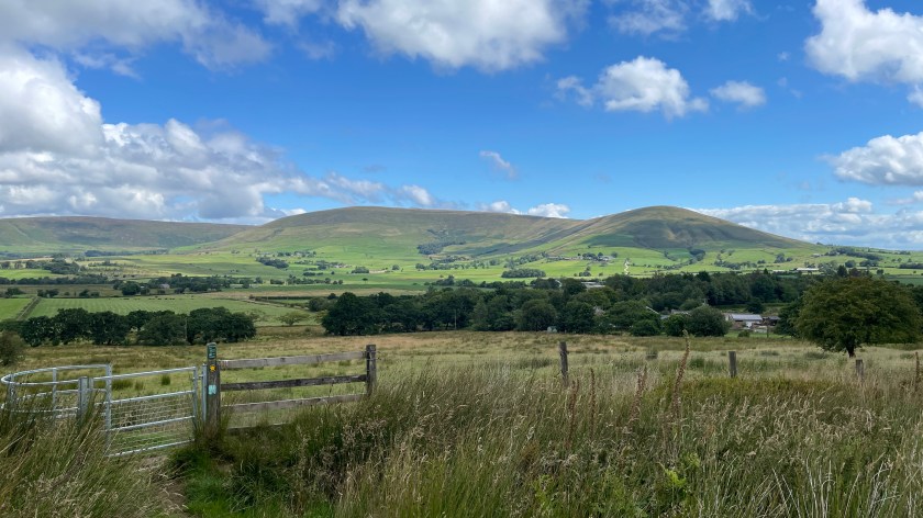
The fell is not very big, but it does sit on the edge of the west Lancashire lowlands giving it spectacular views across to the mountains of both Wales and the Lake District. On a day with good visibility you can see the Isle of Man, most days you can see the Manx ferry making its way in-to, or out-of Heysham. In the opposite direction you get great views of the more substantial Forest of Bowland fells including Parlick and Fair Snape.
As a country park Beacon Fell has good facilities with several car parks, lots of good paths and even a visitors centre with a cafe and toilets.
The Walk
This walk starts from the Sheepfold Car Park. There are a couple of reasons for this, the first is that this car park is free, unlike the one at the visitors centre although the one at the visitor centre only charges £1 for the day. The second reason is that there’s a back route to get here without travelling half of the circular one-way road around the fell.
I’ve called it ‘up hill and down dale’ because that’s the order I did the walk. I tend to prefer walks that go up and then come down, even if that means going down first to go up. This walk goes the other way around, you finish by going up, there’s really no way of avoiding that as the car park really isn’t very far from the top. You could minimise the amount of up at the end by doing the walk the other way around, that way around the walk back up to the car park wouldn’t be as steep.
This walk starts on the wide, well marked, paths of the Beacon Fell Country Park travelling around the park first before veering off into the surrounding farmland.
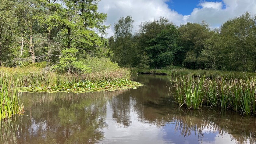
From the car park we are heading towards The Tarn along Larch Avenue which was previously the road up to a farm which stood where the visitors centre is now. It’s worth spending a little bit of time at The Tarn where the Dragonflies and Damselflies can be glorious.
There a little bit of tricky navigating here if you want to follow the same route as me, there are several paths that all converge here. You are aiming for the circular route that takes you between Quarry Wood and Quarry Car Parks. Don’t worry if you miss this and find yourself on a different route to the summit, that’s where you are heading eventually.
Part way along the circular route there’s a short cut-back connecting path that puts you on a path to the top. It’s worth taking what feels like a detour to experience the views on any day, but especially when the visibility is good.
Having reached the trig-point at the top it’s time to head back down to the circular path, but only for a short while. You are aiming for a point on this path where there is a sculpture known as The Lizard Love Seat on your left and a gate with a path heading down hill on your right which will take us down-dale.
Up to this point you could travel this walk almost any day of the year, beyond here we start to move into farmland and some of it is particularly boggy, so I don’t recommend it as a winter walk. This year has been dry for weeks and it was still wet in places. There’s no need to do this piece of the walk, if you want to get back to you car you can simply stay on he circular route. This part of the route is there to add interest and some different views.
At this point you should be heading down to the circular road then across the road down toward Sagar’s Farm (no idea who Sagar was), the path is marked by some nicely placed yellow topped posts. Before you get to Sagar’s farm, though, you’ll reach a not very well defined hedgerow cutting across your path, at this point you want to turn left along the line of the hedgerow.
The views of the Forest of Bowland Fells from here are spectacular. If you are fortunate you may even see a glider heading off from the nearby club, paraglider are also quite common floating off the top of the larger fells.
You are heading toward North Nook across a series of boggy fields via a set of stiles, each one marked by a yellow pole. All you have to do is find the stiles which isn’t always easy.
Just before North Nook you cross a road and along a path that feels a bit like you are walking through someone’s garden. Across the garden are two stiles close together. Once you come out the other side you are looking for a tall stile which isn’t quite where it’s marked on the OS map.
You’ll now make your way through some young woodland and then out into some more open scrub. You are looking for a path heading left on a steep incline. You are heading up into an area known as the Rosemary Bullivant Memorial Forest where each of the trees is dedicated to someone.
From the Memorial Forest you work your way to the right either via the visitors centre and toilets, or a less travelled route via the Jubilee Memorial.
There’s a path from the end of the visitor centre car park, across from the Orme sculpture, that takes you back up onto Larch Avenue and back to the Sheepfold car park.
Alternatives and Variations
There are so many variations to this walk I nearly didn’t write any. The country park is criss-crossed with paths that you can use to shorten or elongate this walk. I’ve already mentioned the option of missing out the down-dale part but then it would only be half the walk.
You can start the walk in one of the other car parks the walk passes nearby to most of them.
There are several sculptures around the park; this route only passes a couple of them, you can add in more of them if you head straight to the top from Sheepfold, passing the Heron, the Walking Snake and the Bat as you go. From there you can partially double back down to the tarn, or head down to the circular route and the Lizard Kissing Chair.
On the map there are various options from extending the down-dale part of the walk also, but I’ve not walked any of them so can’t comment on their suitability.
Larch AvenueThe TarnFrom the topSome more of the view from the topAcross the boggy bit – look out for the yellow topped postsThe view across to Parlick and Fair Snape from the down-dale bitBack to the top
Tarn Hows is a popular destination. If you want a walk where you don’t see anyone, this is not the place. This popularity isn’t anything new, Charabanc would travel up from Ambleside and Windermere in the 1890s. That said, I’ve never known the tarn to be over-run with people; there’s plenty of space to spread out and there’s probably less public transport now than there was in the days of the charabanc.
The walk starts from the Glen Mary Bridge car park, a name that was given to the local area by John Ruskin who thought that the name Tom Gill wasn’t picturesque enough. It is a picturesque. It’s a National Trust car park making it free for members. Much of the land around here is owned and operated by the National Trust including the tarn itself, I’ll talk a bit more about that later.
(It’s worth noting here that a “gill” is a local Cumbrian name for a valley with a stream in it, with Scandinavian roots. A “glen” is a Scottish name for the same thing.)
If Glen Mary car park is full, which it can do, there are a few other parking spaces just off the main road alongside Yew Tree Tarn from where you can also begin this dainty walk.
This is a walk of two halves. The first part takes you rambling up through an ancient wood alongside a cascading stream, it’s not hard but it is uneven in places. The second part is around the tarn which is more like a promenade than a ramble. The main path around the tarn is flat, wide and well paved.
From the car park there’s a footbridge across the stream which is your guide to the tarn. There aren’t any decisions to make on this route, you follow the well worn path on the ground which follows the general route of the stream. There are several delightful waterfalls on your way up the hill, some you explore via short detours.
Part way up the hill, through a small gate, the cutting narrows significantly, the walking gets a bit more tricky, you’ll struggle to get lost though.
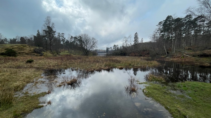
The stream takes you to the tarn where it flows out via a small dam. There used to be three small tarns in this area, the dam raised the water level to join them together into the larger expanse of water we see today. Much of what people assume is natural in the Lake District has been tinkered with by humans.
The tarn is banded by a circular route which brings you back to the dam. On your way around there are several places to drift off the main path to see something of interest, or get a better view. This is a great place to let children explore, there are still plenty of trees to climb even though the area has been heavily impacted by storms over recent years.
The promenade is very picturesque with photo opportunities around many of the corners.
It’s traditional for us to go clockwise around the tarn, so we head left, but could just as easily head right. The end of the tarn is marked by a bridge which is accompanied by a seat with glorious views along the full length of the tarn.
Having promenaded down one side it’s time to do the same along the other.
At the other end of the tarn there’s another car park operated by the National Trust, you could use this as a start to the walk, but where’s the fun in that. There are some toilets at the car park, if you are fortunate there will also be an ice-cream van.
From the ice-cream van head back down to the dam and onto the path back to Glen Mary Bridge.
On the other side of the road from Glen Mary Bridge is Yew Tree Farm which is notable for several reasons. The farm is part of an estate of land known as Monk Coniston which stretches all the way down to the shores of Coniston, and included Tarn Hows. When this land was put up for sale in 1930 a local couple Mr and Mrs Heelis, him a solicitor, her an author and illustrator who is better known as Beatrix Potter, purchased it. They were determined that the estate shouldn’t be broken up or developed. The National Trust wasn’t the large organisation it is today and weren’t in a position to buy the land. Beatrix later donated the land to the National Trust, but with a stipulation, the local Herdwick sheep were to continue on the land, each farm being allocated a minimum headcount.
The Herdwick allocation probably saved the breed from extinction in this area of the Lake District, but it hasn’t always been easy, the wool is course and they develop slowly so you can’t use the lamb meat. In recent years, however, the farmers at Yew Tree farm have found a way of making the Herdwick profitable and now have over 1,000. Sue and I recently spent a wonderful day at the farm on a Herdwick Experience where they tell you about the history of the sheep, about the resulting hogget which is used in several Michelin Starred restaurants in the area and can be purchased from the farm. They also, as part of the experience, take you to meet a group of the sheep who like to be petted. You sit in a field and they join you, sitting alongside you as you scratch their backs.
(A lamb is a sheep that is less than a year old, a hogget is a step between one and two years.)
Oh, yes, also, Yew Tree Farm is one of the main locations for the ‘Miss Potter’ film with Rene Zellwigger and Ewan McGregor.
What about variations?
There aren’t many options for variant walks through the woods along the stream, you can sometimes venture closer to the stream, but that’s about it.
Once you get to Tarn Hows there are a few more options to add in extra distance and difficulty. Near the beginning you can head off to Tom Heights from which there are good views of the surrounding hills (it’s been a few years since I’ve been up there so I’m hoping the views are still there). You can join the Tom Heights path on to the walk up to Black Fell. Black Fell is one of the smaller, and easier, Wainwrights, so you can get an easy tick.
Another route up to Black Fell is from a stile at the end of the Tarn via the Iron Keld Plantation. The path to Iron Keld Plantation can also be used to access a route that circles the tarn from higher up. The higher route gives better views of the surrounding hills and is less well travelled.
From the car park at Tarn Hows there’s a different route back to Glen Mary Bridge, I’ve never walked it so can’t comment.
Glen MaryTom Gill WaterfallTarn HowsTarn Hows near to the car parkYew Tree FarmOne of the friendly Herdwicks
We start this walk from the Pelter Bridge Car Park at the southern/easterly end of Rydal Water near to the village. Pelter Bridge is one of the Lake Districts smaller places to leave your vehicle and can often be full. As an alternative I’ve included instructions when starting from either White Moss Carp Park or Rydal Water Car Park. These car parks are bigger but can also get full.
My walking guides tend not to take you step-by-step through your journey, I prefer to give you an outline of where to go, then make the mapping information available. If you just have the words below I can’t guarantee that I haven’t missed something important.
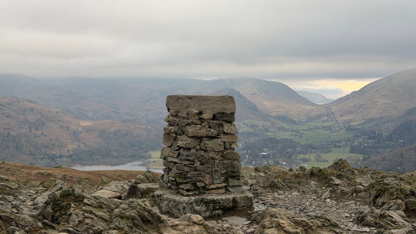
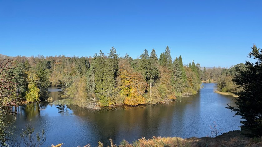
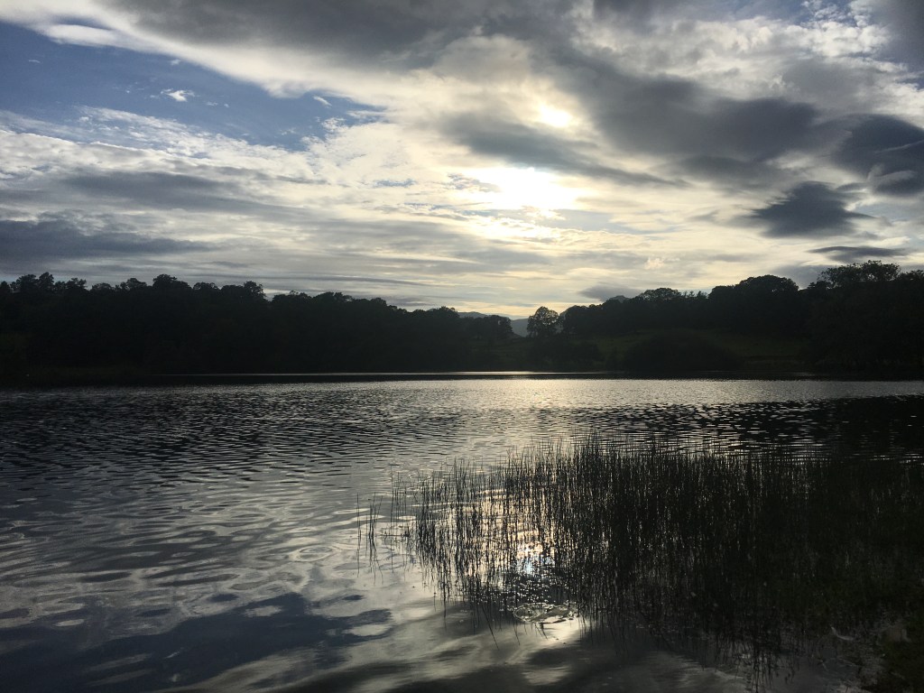
The first part of this walk takes us along the former quarry tracks up to Rydal Cave. Simply head up the road that you’ve just driven on to get to the car park and carry on once you get to the gate at the end. Just after the gate you’ll get your first view across Rydal Water (the header image). You may, at this point, start to feel something poetic building inside you, if you do you wouldn’t be the first. The village of Rydal was the favourite home of the acclaimed poet William Wordsworth, his family, and his sister Dorothy, who deserves far more acclaim than she receives.
Dorothy Wordsworth’s Journals, many written in Rydal and Grasmere, are wonderfully poetic:
After tea we rowed down to Loughrigg Fell, visited the white foxglove, gathered wild strawberries, and walked up to view Rydale. We lay a long time looking at the lake; the shores all dim with the scorching sun. The ferns were turning yellow, that is, here and there one was quite turned. We walked round by Benson’s wood home. The lake was now most still, and reflected the beautiful yellow and blue and purple and grey colours of the sky.
Dorothy Wordsworth
(I don’t know when Rydale became Rydal, other than to note it was at some point after the early 1800s which is when Dorothy was writing.)
You’ll see from this vantage point that there is a path running alongside the lake, we are coming back that way, for now we are going to head up to Rydal Caves keeping left on the higher path.
There is one very famous cave directly on this route which you can go into with ease, but before that there are a few smaller caves which are more challenging to get into. One of the smaller caves used to have a drum kit inside it which sounded amazing. It’s been a while since I’ve been in that cave, as it now requires a rope to get in, so can’t confirm whether the drum kit is still there.
These caves are the result of slate mining and as you work your way along this lane and into the vast cathedral space it is worth remembering that this was a place of noisy, dusty, dangerous toil.
The Lake District is littered with various mines and quarries, the area wouldn’t be the same without them. This is a land shaped by people.
Having stepped inside the large cave and taken in the view and the acoustics, it’s time to carry on along the side of Rydal Water towards Grasmere. I love the views of Nab Scar towering over the diminutive Rydal Water from this elevated position.
As you near the end of Rydal Water there is a fork in the path where you should continue to take the higher option. This path will take you around the corner onto Loughrigg Terrace with elevated views across Grasmere including Helm Crag (also known as the Lion and the Lamb) and Dunmail Riase (remembering the last king of Cumbria who is reportedly buried below the cairn near to the top).
Carry on along Loughrigg Terrace to the end and into the woods. You need to go through one gate at the end of the path and then a slight right through another gate into Red Bank Wood. This is a gentle walk through established trees marking the seasons by their attire.
Eventually you’ll reach a cottage next to the road between Grasmere and Loughrigg Tarn. At the entrance to the driveway for the cottage there is a path to the right which cuts back through the woods heading downhill and on to the lakeside path below Loughrigg Terrace. The beach here is a great place for a swim but can get a bit crowded.
On leaving the beach you’ll come to a wooden footbridge across the stream. You have a choice here, the route I’ve provided takes you along the southern edge of the stream this path can be flooded when the river is high, but rarely. It can also be a bit uneven. If you prefer something a bit more even, you can cross the bridge take a right hand turn on the other side and follow the path along the other side of the river. Both paths meet at a metal bridge.
The metal bridge is where you’d join the route if you’ve parked at either White Moss or Rydal Water car parks.
From the metal bridge head through the woods up the hill until you reach a gate. Through the gate turn left and along the path by the wall. You should be able to see Rydal Water ahead of you. Walk along this path all the way to the other end of the lake. There are several places to swim along this part of the route, it’s also a great place to practice your skimming, there are plenty of flat stones available.
As you near the end of the lake you’ll notice the gate that you came through on your way to the cave higher up on your right. We are going to go through the lower gate. This route takes you through some more woods and along the river where you’ll get views of the boathouse which is a classic Lake District photo opportunity. Soon you’ll come to a footbridge, don’t go over the bridge but head right and up the hill through some woods and onto the car park road. You’ll reach the car park road via a small gate; the car park is down the hill to your left.
There are several variations to this walk:
As hinted a couple of times you can start this route from White Moss Carp Park or Rydal Water Car Park. There are a few reasons why you may choose to do this, the first being parking. The second is access to a toilet which can be found in the woods between White Moss and Rydal Water car parks. The third reason being access to refreshments; there is normally a pop-up coffee van by the side of the stream near to the toilets.
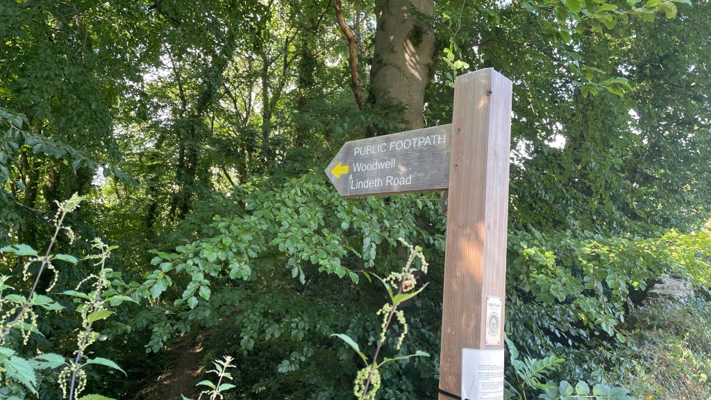
You can extend the walk a bit near the end. Instead of turning right up onto the car park road you can turn left across the footbridge, from there you can cross the road into the village. In the village there are several places of interest.
Almost directly opposite the exit from the footbridge is Dora’s Field which is full of daffodils in the spring. The daffodils were planted as a memorial to one of the Wordsworth’s daughters who died aged 43 of tuberculosis. Dora’s Field has a gate into the church grounds, both the grounds and the church are lovely with even more Wordsworth associations. Up the hill from the church is Rydal Mount where the Wordsworth family lived for a while.
As you go up the hill, before Rydal Mount there is an entrance to the ground of Rydal Hall. The hall is a Christian retreat, but the grounds are open to the public where there are several walks and gardens to explore. Within the ground is one of the Lake District’s most photographed waterfalls with The Grot alongside it. The Grot is a great place to spend some time in quiet. Swimming is not permitted in the waterfall.
Within the grounds of Rydal Hall is the Old School Room Tea Shop which we’ve visited several times and always had great food, but haven’t visited for a while and hence it’s not currently included in Graham’s Cafes.
Another option on this walk is to follow the Coffin Trail along the other shore back to your car, I’m going to cover that route as a whole new guide.
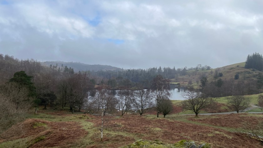
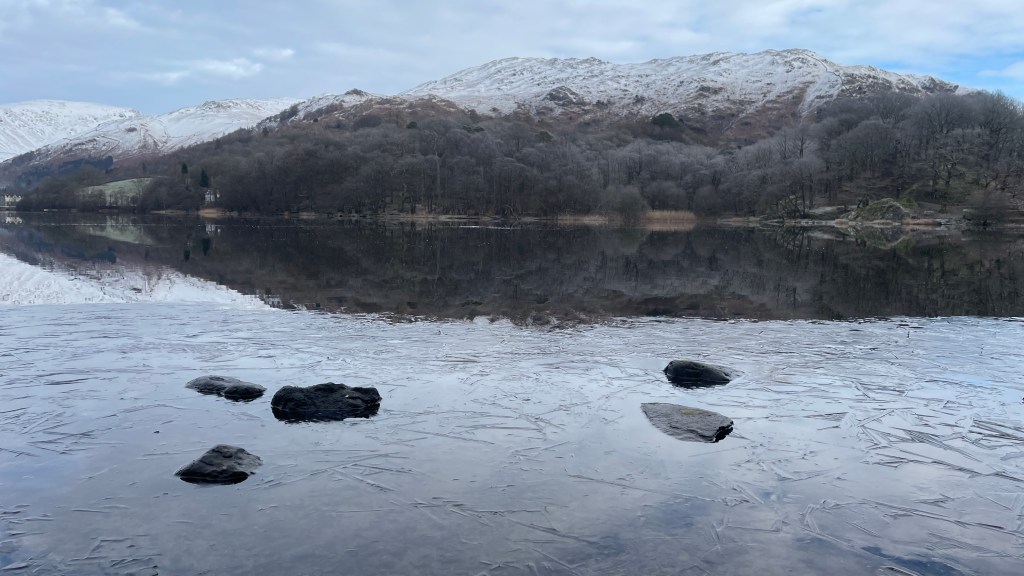
The view across Rydal Water towards GrasmereInside the caveThe view from the start of Loughrigg Terrace towards Grasmere VillageThe view across Grasmere towards Dunmail RaiseA frozen Rydal Water towards Nab ScarThe Daffodils of Dora’s Field
I like to plan walks with a reward half-way around, in today’s walk that reward is the opportunity to swim in a beautiful tranquil tarn.
We start this walk in Skelwith Bridge. If you can, park on the Langdale road (B5343) near to the Skelwith Bridge Hotel. There’s also the option of using the car park another 0.4 mile further up the road or some spaces in the ground of the old slate-works. Don’t park in the hotel car park, or in the Chesters by the River car park.
This is one of those walks where to get a parking space you have to understand the rhythm of tourism in the Lake District. If you arrive on a sunny day in the middle of the morning through to the middle of the afternoon you aren’t likely to be able to park, especially if it’s a school holiday or a weekend. You may be fortunate, but you can’t rely upon it. Arrive earlier, or later, than that and you’ll have a much better chance of getting parked, these are also the times with the best light and hence the best views.
For us this is either an early morning walk with lunch back at Chesters by the River, or it’s an afternoon, into the evening, walk with a picnic tea.
We normally take our time on this walk, it’s a tramp, it’s not a route-march.
Opposite the Skelwith Bridge Hotel is a kissing gate with an easily identifiable path up the hill to another gate. Here the path is more narrow and uneven, it’s only for a short distance but is the reason I mark this route as Moderate. There’s something soothing about walking in the dappled light of a wood especially when the birds are singing.
Soon you’ll come out into the Neaum Crag holiday park where the route through is reasonably well marked. You are heading straight across, past the pool and up the hill which veers to the left. This is where, in the winter, this walk can get a bit icy.
At the top of the hill there’s another gate out into open countryside. Soon you’ll be rewarded with views of Loughrigg Fell and the Langdales in the distance followed shortly afterwards by views of the tarn. In the spring you’ll be greeted by Bluebells, in the summer by Bracken. The path traverses a bank, downwards towards the road past a quintessentially Lake District farm at Loughrigg Fold.
Once you’ve reached the road follow it to the left for a short distance before you arrive at a stile on the right. The path around the lake is quite clear here, across the field, through another gate, across another field right alongside the tarn.
If you are planning to swim there are numerous options here, some have shade, some in the open. The further round you go the better your view across the tarn and back towards the Langdales. These views are particularly magical at sunset. A favourite swimming spot for many is marked by a lone tree that bends out over the tarn.
In the spring and early summer, Cuckoos and Woodpecker can often be heard in the woods nearby. The Waterlillies are gorgeous in the summer and so is the cruely named Bogbean.
Fortunately, this place of beauty is remote enough to avoid being overcrowded. We’ve never been when it has resembled the more popular tourist locations just a few miles down the road. There are often a few other groups, but each of them respecting the tranquillity of the place.
Please note that you aren’t allowed to take craft or inflatables onto the tarn, this isn’t Bowness.
Once you’ve finished your swim, picnic, yoga, contemplations, or whether it is you do in such a place, continue on the path towards a small gate in the fence by the lane. Through the gate turn right. Take the lane around to the road, and then the road back to Loughrigg Fold. The road is generally quiet, but please remember, you are sharing the space with vehicles.
From Loughrigg Fold retrace your route up the lane, into Neaum Cragg Holiday Park and eventually back down to your vehicle.
There are some variations on this walk:
If you have parked in the car park below Neaum Crag, you can take a different path up and over to the tarn. This path brings you down to Loughrigg Fold from where the route is the same as above. Alternatively, you can cross the road and down onto the Elterwater path. If you take a left you can follow the river down towards the waterfalls at Skelwith Force and into the slate-works, from where you can join the path as described. The waterfalls are worth a visit at any time, but especially if the river is high.
If you just want do a circuit of the tarn without all the uphill and downhill bits there are a few car parking spaces just at the point beyond Loughrigg Fold where the path crosses the field. There are only a few and please park sensibly.
You could also extend your walk just a very small amount by incorporating a visit to Chesters by the River, a long time Lake District favourite.
You could massively extend the walk by adding in a trip to the top of Loughrigg Fell but that would make it a completely different walk with a different name.
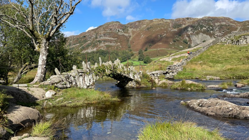
Header Image: Loughrigg Tarn looking up toward Loughrigg Fell.
Most days I enjoy walking straight from my front door. There are plenty of options for a morning walk and getting in a car to go somewhere feels an unnecessary complication. Also, where I live, the main road can become a slow moving carpark making movement slow and frustrating – which is somewhat counter to the purpose of going for a walk.
There are some days, though, when I want to mix things up a bit and this little walk is a very short drive for a welcome change of scenery.
Brockholes is a local Wildlife Trust Nature Reserve situated in a former sand-pit. At one side it is enclosed by the River Ribble, along another side it’s the M6, around two other sides are wooded banks. Through the middle runs the Guild Wheel which also provides us with the pathway for the start of this walk.
Brockholes is worth a visit with its floating visitor village, play area, wildlife hides and country walks. It’s easily accessible off J31 of the M6. The only charge is to park and as this walk start by parking elsewhere that doesn’t apply. Because of that I would encourage you to think about how you might contribute financially to the nature reserve.
(Note: There is also a Brockhole (without the ‘s’) between Windermere and Ambleside, don’t get the two confused.)
My walk starts at Preston Crematorium which is accessed via a long tree-lined drive off Longridge Road. Part way along the drive is a small carpark on outward side of the road, followed by another small carpark on the inward side. Park in the outward side carpark if you can, the path runs alongside.
Note: The driveway to the crematorium has gates and they are closed in an evening. There are different opening times for Winter and Summer. Please make sure that you check that you will be able to get your car out at the end of your walk. There is always a notice at the gate and one at the start of the path, the opening times are also on the web site.
At the start of the path, we are on the Guild Wheel which is nicely tarmacked for cyclists and pedestrians alike. This is a shared path, and you should expect to see cyclists.
There is some historical interest in this area. The walk starts in the grounds of the former Red Scar House, home of one William Cross who also helped to model Winckley Square in Preston. The house is long gone, having been demolished in 1939, but you can still see the basic outline of the grounds in the trees that remain. The adjacent industrial estate, for which the house was demolished, then became Courtaulds Red Scar Works one of the largest producers of rayon in Britain and employing 4,000 people. The Courtaulds days came to an end in 1979, but local people still refer to as by that name.
From the carpark, I follow the Guild Wheel through the woods, across some more open land towards Red Scar Woods. It’s springtime and the trees are in full leaf, but I can still catch glimpses of the River Ribble, and the Ribble Valley views beyond.
The tarmacked section eventually runs out just about where there’s a fork in the path. I take the path to the left alongside the woods and then, eventually, into the woods and down the hill. The hill is moderately steep and can be slippery.
At the bottom of the hill, I take a path off to the left towards the river. The river is tidal at this point and different every time. Depending on the time of year this is a great place to see kingfisher, sand-martins and various other waterfowl. On this occasion it’s too early for the sand-martin and no blue flash of a kingfishers either. I’m still hoping to see an otter.
There’s something therapeutic about walking alongside water, it’s flowing gently today. The river can flood here and needs to be treated with respect.
You can walk alongside the river all the way into Preston, but I only go as far as the entrance to the nature reserve, continuing to the right alongside the M6.
One evening I stood for several minutes watching a barn owl hunting in this section. They are magical to watch, silently, effortlessly flapping and gliding then suddenly dropping like a stone. I take a short diversion to sit in one of the hides overlooking the ponds, the ponds are a great place to watch Starling murmuration. The starlings don’t always nest in the same place, so you do need to track them down.
I steadily work my way back to the bottom of the hill, then it’s back to the top and along the woods to the car. In the early spring the wooded bank that I came down and need to climb are adorned with bluebells, this wood is also a wonderful place to see the local deer.
There are a few variations to this walk:
The route outlined skirts around the edge of the reserve, if you want to see the visitor village where there are toilets and a cafe, there are several places where you can branch off.
If you do branch off to the visitor village there are several other hides to explore. One of the hides is regularly visited by a local Kestrel, known as Kevin, who is happy to show off their hunting prowess.
At the start of the walk there are several options to walk through the woods before you go down the banking. Some of these are more arduous than others but will give you better views of the panorama when the leaves are on the trees.
You can also drive into the nature reserve, park up, and explore from there. This is an especially useful option if you are looking for a walk without a hill.
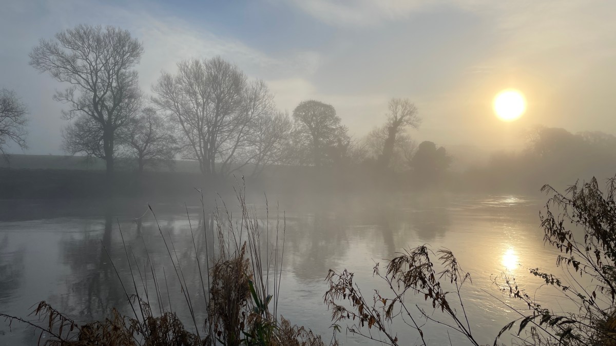
Header Image: The view across the Ribble on a misty morning.
Here in the UK we like a seaside promenade on a sunny day, taking in the blue skies and sea.
However, the British weather is never guaranteed, which means we are conditioned to be just as happy walking along a windy promenade on a cloudy day with the white capped waves careering into the sands. It was precisely these conditions that greeted me as I parked in the promenade car park at Rossall Beach on a recent Sunday afternoon.
There are several places to walk along the Fylde coast each with their own charms. The charm of Rossall Beach is that it’s a quiet sandy beach where you get great views across to Morecambe Bay to the Lake District and even as far as the Isle of Man. If you want fish-and-chip shops, ice-cream parlours and amusement arcades you need to be a few miles further south. Rossall Beach is more rural, although also, almost suburban.
From the Rossall Beach promenade car park I head north along the beach taking in the changing skies and relishing in the occasional burst of sunshine sparkling off the Irish Sea. I’m conscious that the wind is on my back and that, at some point, I am going to need to turn around and walk directly into it. The tide is on its way out and there’s ample firm sand to walk on. It’s a shorts and jumpers day.
I’ve set myself the target of getting to the Rossall Point Observation Tower, to give it it’s Sunday name, about 2.5 miles (about 4 km) away. This rather strange structure has various uses including a public observatory. There are also public toilets here.
Part way along I pass Rossall School a place of education since 1844. The buildings are from a different time to everything that surrounds them making it look strangely out of place even though it was here first.
The weather continues to change as I enjoy the scenery, there are a few other people around, but this isn’t a day where the beach is full. I don’t think I’ve ever seen the beach flooded with people here, that’s part of the joy of the place it’s easy to get to but it also feels isolated.
Having reached the tower it’s time to head back facing into the strengthening wind. It looks like the weather may turn to rain so I choose the promenade for my return. There has been lots of work on the sea defenses in recent years including the integration of paths, boulder groins, various seating options and art installations. There’s also areas set aside for nature on the onshore side of the defences forming the Larkholme Grasslands. I particularly like the Sea Swallow sculptures forming part of the Mythic Coast project.
This is a great place for a sunset, not that there is going to be one on this particular day the cloud is thickening fast.
I’m passed by various joggers and cyclists many of whom have the look of people rapidly heading for a safe haven. One young man passes me in short-shorts and a vest top, muscles pumped. He’s in fully Rocky mode punching away at some invisible opponent. He stops not far in-front of me and proceeds to go through a routine of upper-cuts, hooks and jabs, then continues his run. He’s carrying a portable speaker that’s proving musical accompaniment.
Having returned to the car park I look at the houses with views of the sea, that also overlooking the expanse of cars. There are always at least one of them for sale and it’s become obligatory to look them up on Rightmove. Views of the Irish Sea come at a premium.
There are a few variations you can make to this walk.
At the far end of the walk you can choose to walk a bit further and take in the events at the boating lake.
Part way back from the observation tower, you can choose to head inland and make your way via the Larkholme Grasslands. This can make for a less windy return.
You can, also, make the walk to the Observation Tower much shorter by starting at the Rossall Point car park heading south.
Header Image: This is the view of the observation tower from the beach.